Brookville geodata
Brookville (Indiana) is a seat of a second-order administrative division; located in United States in America/Indiana/Indianapolis (GMT-4) time zone. With population of 2,566 people, there are 10466 cities with bigger population in this country. Compared to other cities in United States, 51.4% of cities are located further ↑North; 55.8% of cities are located further ←West and 51.9% of cities have lower elevation than Brookville. Note1
Administrative division(s):
- Level 1: Indiana
- Level 2: Franklin County
- Level 3: Township of Brookville


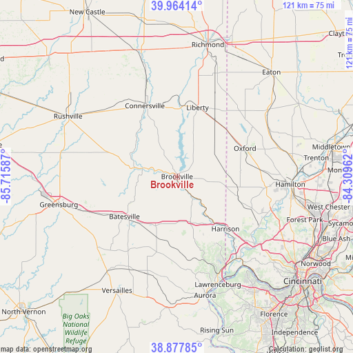
Brookville GPS coordinates[2]
39° 25' 23.196" North, 85° 0' 45.864" West
| Map corner | latitude | longitude |
|---|---|---|
| Upper-left | 39.96414°, | -85.71587° |
| Center: | 39.42311°, | -85.01274° |
| Lower-right: | 38.87785°, | -84.30962° |
| Map W x H: | 120.8×120.8 km | = 75.1×75.1mi |
| max Lat: | 71.29058° ⇑51.4% North |
| Brookville: | 39.42311° |
| min Lat: | ⇓48.6% South 19.06759° |
| min Long | Brookville | max Long |
| -171.73463° | -85.01274° | -66.98998° |
| W 55.8%⇐ | ⇒44.2% E |
Elevation
Elevation of Brookville is 206 m = 676 ft, and this is 88.8 m = 291 ft below average elevation for this country.
| Max E: |
3189 m = 10463 ft | 48.1% |
| Avg. | 294.8 m = 967 ft | |
| Brookville | 206 m = 676 ft | |
Min E: |
-60 m = -197 ft | 51.9% |
See also: United States elevation on elevation.city.
Geographical zone
Brookville is located in North temperate zone (between Tropic of Cancer and the Arctic Circle). Distance of this Northern Tropic circle is 1777.5 km =1104.5 mi to South.| Distance of | km | miles | from Brookville |
|---|---|---|---|
| North Pole | 5623.6 | 3494.3 | to North |
| Arctic Circle | 3017.7 | 1875.1 | to North |
| Tropic Cancer | 1777.5 | 1104.5 | to South |
| Equator | 4383.4 | 2723.7 | to South |


Nearby cities:
15 places around Brookville: (largest is in red/bold)
• Batesville
22.6 km =14 mi,  232°
232°
• Blue Jay
32.2 km =20 mi,  132°
132°
• Bright
26.5 km =16.5 mi,  149°
149°
• Connersville
26.6 km =16.5 mi,  335°
335°
• Darrtown
31.2 km =19.4 mi,  75°
75°
• Harrison
24.4 km =15.2 mi,  137°
137°
• Laurel
17.2 km =10.7 mi,  300°
300°
• Liberty
24.6 km =15.3 mi,  16°
16°
• Millville
31 km =19.3 mi,  96°
96°
• New Haven
28.6 km =17.8 mi, 125°
• Oldenburg
18.9 km =11.7 mi,  240°
240°
• Oxford
24.8 km =15.4 mi,  67°
67°
• Saint Leon
15.3 km =9.5 mi,  162°
162°
• Sunman
21.9 km =13.6 mi,  198°
198°
• West College Corner
23.3 km =14.5 mi,  46°
46°
Sources, notices
• [Note1] Compared only with cities in United States existing in our database
• [Src1] Map data: © OpenStreetMap contributors (CC-BY-SA)
• [Src2] Other city data from geonames.org with taken over terms of usage.
• [Src3] Geographical zone / Annual Mean Temperature by Robert A. Rohde @ Wikipedia
