Ashland geodata
Ashland (Kansas) is a seat of a second-order administrative division; located in United States in America/Chicago (GMT-5) time zone. With population of 816 people, there are 17663 cities with bigger population in this country. Compared to other cities in United States, 65.3% of cities are located further ↑North; 80.5% of cities are located further →East and 89.8% of cities have lower elevation than Ashland. Note1


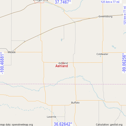
Ashland GPS coordinates[2]
37° 11' 19.104" North, 99° 45' 56.448" West
| Map corner | latitude | longitude |
|---|---|---|
| Upper-left | 37.7467°, | -100.46881° |
| Center: | 37.18864°, | -99.76568° |
| Lower-right: | 36.62642°, | -99.06256° |
| Map W x H: | 124.6×124.6 km | = 77.4×77.4mi |
| max Lat: | 71.29058° ⇑65.3% North |
| Ashland: | 37.18864° |
| min Lat: | ⇓34.7% South 19.06759° |
| min Long | Ashland | max Long |
| -171.73463° | -99.76568° | -66.98998° |
| W 19.5%⇐ | ⇒80.5% E |
Elevation
Elevation of Ashland is 611 m = 2005 ft, and this is 316.2 m = 1037 ft above average elevation for this country.
| Max E: |
3189 m = 10463 ft | 10.2% |
| Ashland | 611 m 2005 ft | |
| Avg. | 294.8 m = 967 ft | |
Min E: |
-60 m = -197 ft | 89.8% |
See also: United States elevation on elevation.city.
Geographical zone
Ashland is located in North temperate zone (between Tropic of Cancer and the Arctic Circle). Distance of this Northern Tropic circle is 1529.1 km =950.1 mi to South.| Distance of | km | miles | from Ashland |
|---|---|---|---|
| North Pole | 5872.1 | 3648.8 | to North |
| Arctic Circle | 3266.2 | 2029.5 | to North |
| Tropic Cancer | 1529.1 | 950.1 | to South |
| Equator | 4135 | 2569.4 | to South |


Nearby cities:
15 places around Ashland: (largest is in red/bold)
• Bucklin
41.5 km =25.8 mi,  16°
16°
• Buffalo
41.1 km =25.5 mi,  162°
162°
• Coldwater
39.9 km =24.8 mi,  77°
77°
• Dodge City
66.5 km =41.3 mi,  340°
340°
• Forgan
75.5 km =46.9 mi,  245°
245°
• Fowler
43.9 km =27.3 mi,  299°
299°
• Greensburg
62.2 km =38.6 mi,  42°
42°
• Haviland
75.4 km =46.9 mi,  50°
50°
• Laverne
54.4 km =33.8 mi,  192°
192°
• Meade
52 km =32.3 mi,  281°
281°
• Minneola
35.9 km =22.3 mi,  322°
322°
• Montezuma
75 km =46.6 mi,  307°
307°
• Plains
73.6 km =45.7 mi, 276°
• Spearville
73.5 km =45.7 mi,  0°
0°
• Wilroads Gardens
61.4 km =38.2 mi,  346°
346°
Sources, notices
• [Note1] Compared only with cities in United States existing in our database
• [Src1] Map data: © OpenStreetMap contributors (CC-BY-SA)
• [Src2] Other city data from geonames.org with taken over terms of usage.
• [Src3] Geographical zone / Annual Mean Temperature by Robert A. Rohde @ Wikipedia
