Greensburg geodata
Greensburg (Kansas) is a seat of a second-order administrative division; located in United States in America/Chicago (GMT-5) time zone. With population of 798 people, there are 17827 cities with bigger population in this country. Compared to other cities in United States, 63.7% of cities are located further ↑North; 80.2% of cities are located further →East and 90.8% of cities have lower elevation than Greensburg. Note1


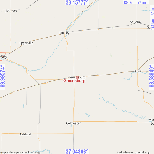
Greensburg GPS coordinates[2]
37° 36' 10.08" North, 99° 17' 33.396" West
| Map corner | latitude | longitude |
|---|---|---|
| Upper-left | 38.15777°, | -99.99574° |
| Center: | 37.6028°, | -99.29261° |
| Lower-right: | 37.04366°, | -98.58949° |
| Map W x H: | 123.9×123.9 km | = 77×77mi |
| max Lat: | 71.29058° ⇑63.7% North |
| Greensburg: | 37.6028° |
| min Lat: | ⇓36.3% South 19.06759° |
| min Long | Greensburg | max Long |
| -171.73463° | -99.29261° | -66.98998° |
| W 19.8%⇐ | ⇒80.2% E |
Elevation
Elevation of Greensburg is 691 m = 2267 ft, and this is 396.2 m = 1300 ft above average elevation for this country.
| Max E: |
3189 m = 10463 ft | 9.2% |
| Greensburg | 691 m 2267 ft | |
| Avg. | 294.8 m = 967 ft | |
Min E: |
-60 m = -197 ft | 90.8% |
See also: United States elevation on elevation.city.
Geographical zone
Greensburg is located in North temperate zone (between Tropic of Cancer and the Arctic Circle). Distance of this Northern Tropic circle is 1575.1 km =978.7 mi to South.| Distance of | km | miles | from Greensburg |
|---|---|---|---|
| North Pole | 5826 | 3620.1 | to North |
| Arctic Circle | 3220.1 | 2000.9 | to North |
| Tropic Cancer | 1575.1 | 978.7 | to South |
| Equator | 4181 | 2598 | to South |


Nearby cities:
15 places around Greensburg: (largest is in red/bold)
• Ashland
62.2 km =38.6 mi,  222°
222°
• Bucklin
30.7 km =19.1 mi,  258°
258°
• Coldwater
37.2 km =23.1 mi,  184°
184°
• Dodge City
65.9 km =40.9 mi,  284°
284°
• Haviland
16.5 km =10.3 mi,  83°
83°
• Kinsley
37.1 km =23.1 mi,  343°
343°
• Larned
66.5 km =41.3 mi,  14°
14°
• Macksville
48.8 km =30.3 mi,  35°
35°
• Medicine Lodge
72.3 km =44.9 mi,  119°
119°
• Minneola
66.1 km =41.1 mi,  254°
254°
• Pratt
49.1 km =30.5 mi, 84°
• Saint John
64.5 km =40.1 mi,  46°
46°
• Spearville
49.2 km =30.6 mi,  303°
303°
• Stafford
72.8 km =45.2 mi,  56°
56°
• Wilroads Gardens
58 km =36 mi, 283°
Sources, notices
• [Note1] Compared only with cities in United States existing in our database
• [Src1] Map data: © OpenStreetMap contributors (CC-BY-SA)
• [Src2] Other city data from geonames.org with taken over terms of usage.
• [Src3] Geographical zone / Annual Mean Temperature by Robert A. Rohde @ Wikipedia
