Cherryvale geodata
Cherryvale (Kansas) is a populated place; located in United States in America/Chicago (GMT-5) time zone. With population of 2,230 people, there are 11272 cities with bigger population in this country. Compared to other cities in United States, 65% of cities are located further ↑North; 72.5% of cities are located further →East and 64.1% of cities have lower elevation than Cherryvale. Note1


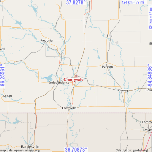
Cherryvale GPS coordinates[2]
37° 16' 13.224" North, 95° 33' 8.928" West
| Map corner | latitude | longitude |
|---|---|---|
| Upper-left | 37.8278°, | -96.25561° |
| Center: | 37.27034°, | -95.55248° |
| Lower-right: | 36.70873°, | -94.84936° |
| Map W x H: | 124.4×124.4 km | = 77.3×77.3mi |
| max Lat: | 71.29058° ⇑65% North |
| Cherryvale: | 37.27034° |
| min Lat: | ⇓35% South 19.06759° |
| min Long | Cherryvale | max Long |
| -171.73463° | -95.55248° | -66.98998° |
| W 27.5%⇐ | ⇒72.5% E |
Elevation
Elevation of Cherryvale is 258 m = 846 ft, and this is 36.8 m = 121 ft below average elevation for this country.
| Max E: |
3189 m = 10463 ft | 35.9% |
| Avg. | 294.8 m = 967 ft | |
| Cherryvale | 258 m = 846 ft | |
Min E: |
-60 m = -197 ft | 64.1% |
See also: United States elevation on elevation.city.
Geographical zone
Cherryvale is located in North temperate zone (between Tropic of Cancer and the Arctic Circle). Distance of this Northern Tropic circle is 1538.2 km =955.8 mi to South.| Distance of | km | miles | from Cherryvale |
|---|---|---|---|
| North Pole | 5863 | 3643.1 | to North |
| Arctic Circle | 3257.1 | 2023.9 | to North |
| Tropic Cancer | 1538.2 | 955.8 | to South |
| Equator | 4144.1 | 2575 | to South |


Nearby cities:
15 places around Cherryvale: (largest is in red/bold)
• Altamont
24.3 km =15.1 mi,  111°
111°
• Caney
44.5 km =27.7 mi,  229°
229°
• Chanute
46.2 km =28.7 mi,  10°
10°
• Chetopa
48.5 km =30.1 mi,  122°
122°
• Coffeyville
26.5 km =16.5 mi,  192°
192°
• Copan
53.1 km =33 mi,  218°
218°
• Erie
42.9 km =26.7 mi,  39°
39°
• Fredonia
38 km =23.6 mi,  320°
320°
• Independence
14.7 km =9.1 mi,  249°
249°
• Neodesha
20 km =12.4 mi,  325°
325°
• Oswego
40.8 km =25.4 mi, 106°
• Parsons
26.9 km =16.7 mi,  73°
73°
• Saint Paul
43.4 km =27 mi,  50°
50°
• Sedan
58.4 km =36.3 mi, 254°
• South Coffeyville
31.3 km =19.4 mi, 191°
Sources, notices
• [Note1] Compared only with cities in United States existing in our database
• [Src1] Map data: © OpenStreetMap contributors (CC-BY-SA)
• [Src2] Other city data from geonames.org with taken over terms of usage.
• [Src3] Geographical zone / Annual Mean Temperature by Robert A. Rohde @ Wikipedia
