Erie geodata
Erie (Kansas) is a seat of a second-order administrative division; located in United States in America/Chicago (GMT-5) time zone. With population of 1,105 people, there are 15644 cities with bigger population in this country. Compared to other cities in United States, 63.8% of cities are located further ↑North; 71.7% of cities are located further →East and 68.2% of cities have lower elevation than Erie. Note1


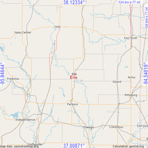
Erie GPS coordinates[2]
37° 34' 5.196" North, 95° 14' 35.916" West
| Map corner | latitude | longitude |
|---|---|---|
| Upper-left | 38.12334°, | -95.94644° |
| Center: | 37.56811°, | -95.24331° |
| Lower-right: | 37.00871°, | -94.54019° |
| Map W x H: | 123.9×123.9 km | = 77×77mi |
| max Lat: | 71.29058° ⇑63.8% North |
| Erie: | 37.56811° |
| min Lat: | ⇓36.2% South 19.06759° |
| min Long | Erie | max Long |
| -171.73463° | -95.24331° | -66.98998° |
| W 28.3%⇐ | ⇒71.7% E |
Elevation
Elevation of Erie is 277 m = 909 ft, and this is 17.8 m = 58 ft below average elevation for this country.
| Max E: |
3189 m = 10463 ft | 31.8% |
| Avg. | 294.8 m = 967 ft | |
| Erie | 277 m = 909 ft | |
Min E: |
-60 m = -197 ft | 68.2% |
See also: United States elevation on elevation.city.
Geographical zone
Erie is located in North temperate zone (between Tropic of Cancer and the Arctic Circle). Distance of this Northern Tropic circle is 1571.3 km =976.4 mi to South.| Distance of | km | miles | from Erie |
|---|---|---|---|
| North Pole | 5829.9 | 3622.5 | to North |
| Arctic Circle | 3224 | 2003.3 | to North |
| Tropic Cancer | 1571.3 | 976.4 | to South |
| Equator | 4177.2 | 2595.6 | to South |


Nearby cities:
15 places around Erie: (largest is in red/bold)
• Altamont
42.3 km =26.3 mi,  186°
186°
• Arma
47.9 km =29.8 mi,  93°
93°
• Chanute
22.5 km =14 mi,  303°
303°
• Cherokee
45.6 km =28.3 mi,  122°
122°
• Cherryvale
42.9 km =26.7 mi,  219°
219°
• Gas
40.6 km =25.2 mi,  347°
347°
• Girard
36.3 km =22.6 mi,  100°
100°
• Humboldt
31.9 km =19.8 mi,  327°
327°
• Iola
42 km =26.1 mi,  340°
340°
• La Harpe
39.1 km =24.3 mi, 352°
• Moran
39.2 km =24.4 mi,  9°
9°
• Neodesha
42 km =26.1 mi,  246°
246°
• Oswego
46.1 km =28.6 mi,  165°
165°
• Parsons
25.4 km =15.8 mi,  183°
183°
• Saint Paul
8.2 km =5.1 mi,  131°
131°
Sources, notices
• [Note1] Compared only with cities in United States existing in our database
• [Src1] Map data: © OpenStreetMap contributors (CC-BY-SA)
• [Src2] Other city data from geonames.org with taken over terms of usage.
• [Src3] Geographical zone / Annual Mean Temperature by Robert A. Rohde @ Wikipedia
