Audubon Park geodata
Audubon Park (Kentucky) is a populated place; located in United States in America/Kentucky/Louisville (GMT-4) time zone. With population of 1,508 people, there are 13621 cities with bigger population in this country. Compared to other cities in United States, 60.6% of cities are located further ↑North; 53.7% of cities are located further ←West and 57.8% of cities have higher elevation than Audubon Park. Note1


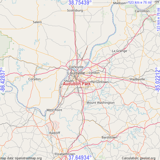
Audubon Park GPS coordinates[2]
38° 12' 14.256" North, 85° 43' 30.864" West
| Map corner | latitude | longitude |
|---|---|---|
| Upper-left | 38.75439°, | -86.42837° |
| Center: | 38.20396°, | -85.72524° |
| Lower-right: | 37.64934°, | -85.02212° |
| Map W x H: | 122.9×122.9 km | = 76.4×76.4mi |
| max Lat: | 71.29058° ⇑60.6% North |
| Audubon Park: | 38.20396° |
| min Lat: | ⇓39.4% South 19.06759° |
| min Long | Audubon Park | max Long |
| -171.73463° | -85.72524° | -66.98998° |
| W 53.7%⇐ | ⇒46.3% E |
Elevation
Elevation of Audubon Park is 166 m = 545 ft, and this is 128.8 m = 423 ft below average elevation for this country.
| Max E: |
3189 m = 10463 ft | 57.8% |
| Avg. | 294.8 m = 967 ft | |
| Audubon Park | 166 m = 545 ft | |
Min E: |
-60 m = -197 ft | 42.2% |
See also: United States elevation on elevation.city.
Geographical zone
Audubon Park is located in North temperate zone (between Tropic of Cancer and the Arctic Circle). Distance of this Northern Tropic circle is 1642 km =1020.3 mi to South.| Distance of | km | miles | from Audubon Park |
|---|---|---|---|
| North Pole | 5759.2 | 3578.6 | to North |
| Arctic Circle | 3153.3 | 1959.4 | to North |
| Tropic Cancer | 1642 | 1020.3 | to South |
| Equator | 4247.9 | 2639.5 | to South |


Nearby cities:
15 places around Audubon Park: (largest is in red/bold)
• Buechel
6.5 km =4 mi,  98°
98°
• Jeffersonville
8.3 km =5.2 mi,  352°
352°
• Louisville
6.3 km =3.9 mi,  331°
331°
• Lynnview
3.2 km =2 mi,  154°
154°
• Newburg
7.5 km =4.7 mi,  130°
130°
• Okolona
7.7 km =4.8 mi, 154°
• Parkway Village
1.6 km =1 mi,  306°
306°
• Rolling Fields
8.5 km =5.3 mi,  33°
33°
• Saint Matthews
8.1 km =5 mi,  48°
48°
• Seneca Gardens
5 km =3.1 mi,  56°
56°
• Shively
8.5 km =5.3 mi,  267°
267°
• Strathmoor Village
4.7 km =2.9 mi, 62°
• Watterson Park
3.9 km =2.4 mi,  109°
109°
• Wellington
5.1 km =3.2 mi,  74°
74°
• West Buechel
5.5 km =3.4 mi, 98°
Sources, notices
• [Note1] Compared only with cities in United States existing in our database
• [Src1] Map data: © OpenStreetMap contributors (CC-BY-SA)
• [Src2] Other city data from geonames.org with taken over terms of usage.
• [Src3] Geographical zone / Annual Mean Temperature by Robert A. Rohde @ Wikipedia
