Eminence geodata
Eminence (Kentucky) is a populated place; located in United States in America/New_York (GMT-4) time zone. With population of 2,535 people, there are 10531 cities with bigger population in this country. Compared to other cities in United States, 59.5% of cities are located further ↑North; 55.4% of cities are located further ←West and 69.7% of cities have lower elevation than Eminence. Note1


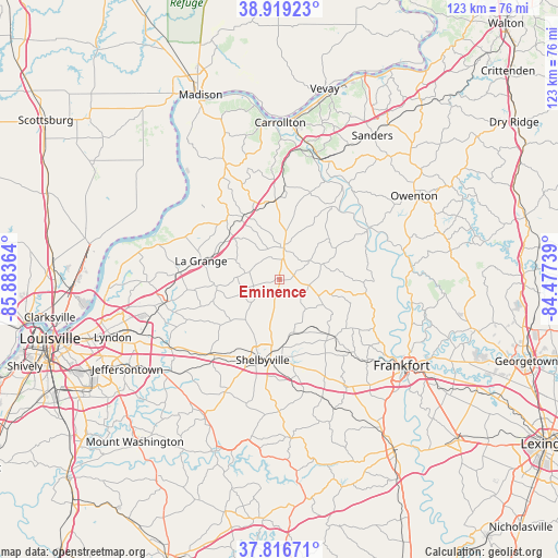
Eminence GPS coordinates[2]
38° 22' 12.252" North, 85° 10' 49.836" West
| Map corner | latitude | longitude |
|---|---|---|
| Upper-left | 38.91923°, | -85.88364° |
| Center: | 38.37007°, | -85.18051° |
| Lower-right: | 37.81671°, | -84.47739° |
| Map W x H: | 122.6×122.6 km | = 76.2×76.2mi |
| max Lat: | 71.29058° ⇑59.5% North |
| Eminence: | 38.37007° |
| min Lat: | ⇓40.5% South 19.06759° |
| min Long | Eminence | max Long |
| -171.73463° | -85.18051° | -66.98998° |
| W 55.4%⇐ | ⇒44.6% E |
Elevation
Elevation of Eminence is 284 m = 932 ft, and this is 10.8 m = 35 ft below average elevation for this country.
| Max E: |
3189 m = 10463 ft | 30.3% |
| Avg. | 294.8 m = 967 ft | |
| Eminence | 284 m = 932 ft | |
Min E: |
-60 m = -197 ft | 69.7% |
See also: United States elevation on elevation.city.
Geographical zone
Eminence is located in North temperate zone (between Tropic of Cancer and the Arctic Circle). Distance of this Northern Tropic circle is 1660.4 km =1031.7 mi to South.| Distance of | km | miles | from Eminence |
|---|---|---|---|
| North Pole | 5740.7 | 3567.1 | to North |
| Arctic Circle | 3134.8 | 1947.9 | to North |
| Tropic Cancer | 1660.4 | 1031.7 | to South |
| Equator | 4266.4 | 2651 | to South |


Nearby cities:
15 places around Eminence: (largest is in red/bold)
• Bedford
27.5 km =17.1 mi,  334°
334°
• Buckner
22.7 km =14.1 mi,  273°
273°
• Campbellsburg
17.2 km =10.7 mi,  353°
353°
• Coldstream
30.6 km =19 mi,  258°
258°
• Crestwood
26 km =16.2 mi, 258°
• La Grange
17.8 km =11.1 mi,  283°
283°
• New Castle
7.1 km =4.4 mi,  7°
7°
• Orchard Grass Hills
30.2 km =18.8 mi, 260°
• Park Lake
25.7 km =16 mi, 263°
• Pewee Valley
27.6 km =17.1 mi, 256°
• Pleasureville
6.3 km =3.9 mi,  115°
115°
• Providence
23 km =14.3 mi, 351°
• Shelbyville
18 km =11.2 mi,  192°
192°
• Simpsonville
22.4 km =13.9 mi,  222°
222°
• Worthington Hills
31 km =19.3 mi, 257°
Sources, notices
• [Note1] Compared only with cities in United States existing in our database
• [Src1] Map data: © OpenStreetMap contributors (CC-BY-SA)
• [Src2] Other city data from geonames.org with taken over terms of usage.
• [Src3] Geographical zone / Annual Mean Temperature by Robert A. Rohde @ Wikipedia
