Shelbyville geodata
Shelbyville (Kentucky) is a seat of a second-order administrative division; located in United States in America/New_York (GMT-4) time zone. With population of 15,253 people, there are 3197 cities with bigger population in this country. Compared to other cities in United States, 60.6% of cities are located further ↑North; 55.3% of cities are located further ←West and 59% of cities have lower elevation than Shelbyville. Note1


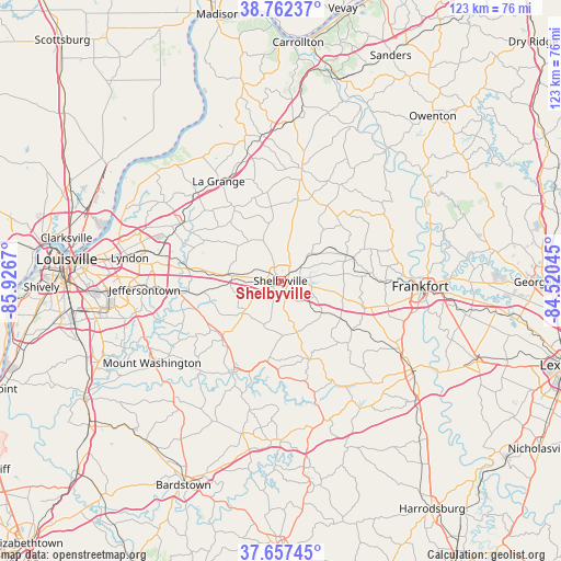
Shelbyville GPS coordinates[2]
38° 12' 43.236" North, 85° 13' 24.852" West
| Map corner | latitude | longitude |
|---|---|---|
| Upper-left | 38.76237°, | -85.9267° |
| Center: | 38.21201°, | -85.22357° |
| Lower-right: | 37.65745°, | -84.52045° |
| Map W x H: | 122.9×122.9 km | = 76.4×76.4mi |
| max Lat: | 71.29058° ⇑60.6% North |
| Shelbyville: | 38.21201° |
| min Lat: | ⇓39.4% South 19.06759° |
| min Long | Shelbyville | max Long |
| -171.73463° | -85.22357° | -66.98998° |
| W 55.3%⇐ | ⇒44.7% E |
Elevation
Elevation of Shelbyville is 235 m = 771 ft, and this is 59.8 m = 196 ft below average elevation for this country.
| Max E: |
3189 m = 10463 ft | 41% |
| Avg. | 294.8 m = 967 ft | |
| Shelbyville | 235 m = 771 ft | |
Min E: |
-60 m = -197 ft | 59% |
See also: United States elevation on elevation.city.
Geographical zone
Shelbyville is located in North temperate zone (between Tropic of Cancer and the Arctic Circle). Distance of this Northern Tropic circle is 1642.9 km =1020.9 mi to South.| Distance of | km | miles | from Shelbyville |
|---|---|---|---|
| North Pole | 5758.3 | 3578 | to North |
| Arctic Circle | 3152.4 | 1958.8 | to North |
| Tropic Cancer | 1642.9 | 1020.9 | to South |
| Equator | 4248.8 | 2640.1 | to South |


Nearby cities:
15 places around Shelbyville: (largest is in red/bold)
• Anchorage
27.7 km =17.2 mi,  282°
282°
• Buckner
26.8 km =16.7 mi,  315°
315°
• Crestwood
25.1 km =15.6 mi,  299°
299°
• Elk Creek
17.9 km =11.1 mi,  226°
226°
• Eminence
18 km =11.2 mi,  12°
12°
• La Grange
25.6 km =15.9 mi,  328°
328°
• Middletown
27.8 km =17.3 mi, 277°
• New Castle
25.1 km =15.6 mi, 10°
• Park Lake
26.3 km =16.3 mi, 304°
• Pewee Valley
25.5 km =15.8 mi, 295°
• Pleasureville
17.6 km =10.9 mi,  32°
32°
• Simpsonville
11.6 km =7.2 mi, 275°
• Taylorsville
22.6 km =14 mi,  207°
207°
• Woodland Hills
26.4 km =16.4 mi, 276°
• Worthington Hills
28.6 km =17.8 mi,  292°
292°
Sources, notices
• [Note1] Compared only with cities in United States existing in our database
• [Src1] Map data: © OpenStreetMap contributors (CC-BY-SA)
• [Src2] Other city data from geonames.org with taken over terms of usage.
• [Src3] Geographical zone / Annual Mean Temperature by Robert A. Rohde @ Wikipedia
