Evarts geodata
Evarts (Kentucky) is a populated place; located in United States in America/New_York (GMT-4) time zone. With population of 962 people, there are 16552 cities with bigger population in this country. Compared to other cities in United States, 66.7% of cities are located further ↑North; 61.4% of cities are located further ←West and 86.9% of cities have lower elevation than Evarts. Note1


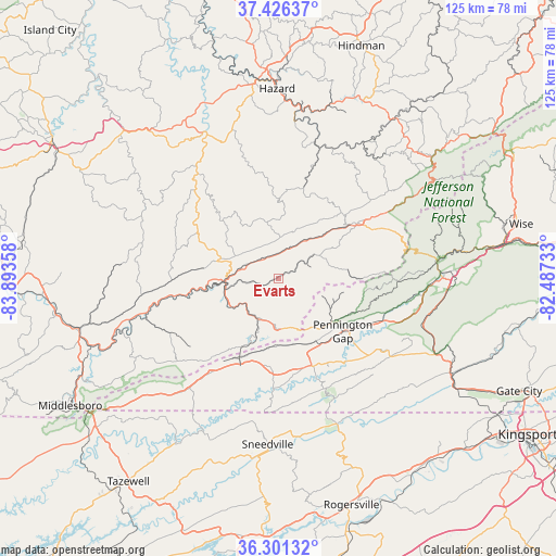
Evarts GPS coordinates[2]
36° 51' 57.312" North, 83° 11' 25.62" West
| Map corner | latitude | longitude |
|---|---|---|
| Upper-left | 37.42637°, | -83.89358° |
| Center: | 36.86592°, | -83.19045° |
| Lower-right: | 36.30132°, | -82.48733° |
| Map W x H: | 125.1×125.1 km | = 77.7×77.7mi |
| max Lat: | 71.29058° ⇑66.7% North |
| Evarts: | 36.86592° |
| min Lat: | ⇓33.3% South 19.06759° |
| min Long | Evarts | max Long |
| -171.73463° | -83.19045° | -66.98998° |
| W 61.4%⇐ | ⇒38.6% E |
Elevation
Elevation of Evarts is 465 m = 1526 ft, and this is 170.2 m = 558 ft above average elevation for this country.
| Max E: |
3189 m = 10463 ft | 13.1% |
| Evarts | 465 m 1526 ft | |
| Avg. | 294.8 m = 967 ft | |
Min E: |
-60 m = -197 ft | 86.9% |
See also: United States elevation on elevation.city.
Geographical zone
Evarts is located in North temperate zone (between Tropic of Cancer and the Arctic Circle). Distance of this Northern Tropic circle is 1493.2 km =927.8 mi to South.| Distance of | km | miles | from Evarts |
|---|---|---|---|
| North Pole | 5908 | 3671.1 | to North |
| Arctic Circle | 3302.1 | 2051.8 | to North |
| Tropic Cancer | 1493.2 | 927.8 | to South |
| Equator | 4099.1 | 2547.1 | to South |


Nearby cities:
15 places around Evarts: (largest is in red/bold)
• Appalachia
36.6 km =22.7 mi,  82°
82°
• Big Stone Gap
39.5 km =24.5 mi,  87°
87°
• Cawood
9.7 km =6 mi,  200°
200°
• Cumberland
21.9 km =13.6 mi,  55°
55°
• Dryden
24.2 km =15 mi,  113°
113°
• Harlan
12 km =7.5 mi,  257°
257°
• Hazard
42.7 km =26.5 mi,  359°
359°
• Hyden
36.6 km =22.7 mi,  333°
333°
• Jonesville
20.9 km =13 mi,  160°
160°
• Loyall
14.6 km =9.1 mi, 263°
• Lynch
26.3 km =16.3 mi, 64°
• Pennington Gap
18.8 km =11.7 mi,  129°
129°
• Rose Hill
26.7 km =16.6 mi,  216°
216°
• Sneedville
37.4 km =23.2 mi,  183°
183°
• South Wallins
20.4 km =12.7 mi,  253°
253°
Sources, notices
• [Note1] Compared only with cities in United States existing in our database
• [Src1] Map data: © OpenStreetMap contributors (CC-BY-SA)
• [Src2] Other city data from geonames.org with taken over terms of usage.
• [Src3] Geographical zone / Annual Mean Temperature by Robert A. Rohde @ Wikipedia
