Sneedville geodata
Sneedville (Tennessee) is a seat of a second-order administrative division; located in United States in America/New_York (GMT-4) time zone. With population of 1,346 people, there are 14369 cities with bigger population in this country. Compared to other cities in United States, 68% of cities are located further ↑North; 61.4% of cities are located further ←West and 80.6% of cities have lower elevation than Sneedville. Note1


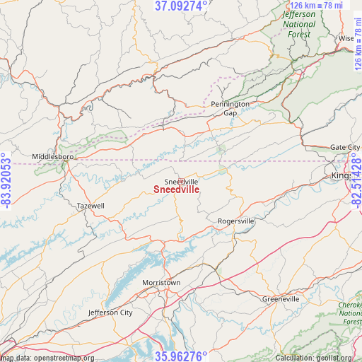
Sneedville GPS coordinates[2]
36° 31' 47.316" North, 83° 13' 2.64" West
| Map corner | latitude | longitude |
|---|---|---|
| Upper-left | 37.09274°, | -83.92053° |
| Center: | 36.52981°, | -83.2174° |
| Lower-right: | 35.96276°, | -82.51428° |
| Map W x H: | 125.6×125.6 km | = 78×78mi |
| max Lat: | 71.29058° ⇑68% North |
| Sneedville: | 36.52981° |
| min Lat: | ⇓32% South 19.06759° |
| min Long | Sneedville | max Long |
| -171.73463° | -83.2174° | -66.98998° |
| W 61.4%⇐ | ⇒38.6% E |
Elevation
Elevation of Sneedville is 360 m = 1181 ft, and this is 65.2 m = 214 ft above average elevation for this country.
| Max E: |
3189 m = 10463 ft | 19.4% |
| Sneedville | 360 m 1181 ft | |
| Avg. | 294.8 m = 967 ft | |
Min E: |
-60 m = -197 ft | 80.6% |
See also: United States elevation on elevation.city.
Geographical zone
Sneedville is located in North temperate zone (between Tropic of Cancer and the Arctic Circle). Distance of this Northern Tropic circle is 1455.8 km =904.6 mi to South.| Distance of | km | miles | from Sneedville |
|---|---|---|---|
| North Pole | 5945.3 | 3694.2 | to North |
| Arctic Circle | 3339.4 | 2075 | to North |
| Tropic Cancer | 1455.8 | 904.6 | to South |
| Equator | 4061.7 | 2523.8 | to South |


Nearby cities:
15 places around Sneedville: (largest is in red/bold)
• Bean Station
21.5 km =13.4 mi,  196°
196°
• Bulls Gap
32.5 km =20.2 mi,  158°
158°
• Cawood
28.3 km =17.6 mi,  358°
358°
• Dryden
36.9 km =22.9 mi,  41°
41°
• Harlan
36.1 km =22.4 mi,  345°
345°
• Jonesville
20.1 km =12.5 mi,  28°
28°
• Mooresburg
20.4 km =12.7 mi,  182°
182°
• Morristown
35.8 km =22.2 mi,  191°
191°
• New Tazewell
35.5 km =22.1 mi,  254°
254°
• Pennington Gap
30.6 km =19 mi, 33°
• Rogersville
23.3 km =14.5 mi,  125°
125°
• Rose Hill
20.7 km =12.9 mi,  319°
319°
• South Wallins
36.1 km =22.4 mi,  331°
331°
• Surgoinsville
33.3 km =20.7 mi,  101°
101°
• Tazewell
32.6 km =20.3 mi,  255°
255°
Sources, notices
• [Note1] Compared only with cities in United States existing in our database
• [Src1] Map data: © OpenStreetMap contributors (CC-BY-SA)
• [Src2] Other city data from geonames.org with taken over terms of usage.
• [Src3] Geographical zone / Annual Mean Temperature by Robert A. Rohde @ Wikipedia
