Hindman geodata
Hindman (Kentucky) is a seat of a second-order administrative division; located in United States in America/New_York (GMT-4) time zone. With population of 741 people, there are 18297 cities with bigger population in this country. Compared to other cities in United States, 64.7% of cities are located further ↑North; 62.1% of cities are located further ←West and 76.3% of cities have lower elevation than Hindman. Note1


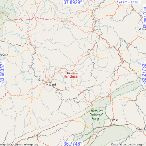
Hindman GPS coordinates[2]
37° 20' 9.348" North, 82° 58' 49.584" West
| Map corner | latitude | longitude |
|---|---|---|
| Upper-left | 37.8929°, | -83.68357° |
| Center: | 37.33593°, | -82.98044° |
| Lower-right: | 36.7748°, | -82.27732° |
| Map W x H: | 124.3×124.3 km | = 77.2×77.2mi |
| max Lat: | 71.29058° ⇑64.7% North |
| Hindman: | 37.33593° |
| min Lat: | ⇓35.3% South 19.06759° |
| min Long | Hindman | max Long |
| -171.73463° | -82.98044° | -66.98998° |
| W 62.1%⇐ | ⇒37.9% E |
Elevation
Elevation of Hindman is 322 m = 1056 ft, and this is 27.2 m = 89 ft above average elevation for this country.
| Max E: |
3189 m = 10463 ft | 23.7% |
| Hindman | 322 m 1056 ft | |
| Avg. | 294.8 m = 967 ft | |
Min E: |
-60 m = -197 ft | 76.3% |
See also: United States elevation on elevation.city.
Geographical zone
Hindman is located in North temperate zone (between Tropic of Cancer and the Arctic Circle). Distance of this Northern Tropic circle is 1545.4 km =960.3 mi to South.| Distance of | km | miles | from Hindman |
|---|---|---|---|
| North Pole | 5855.7 | 3638.6 | to North |
| Arctic Circle | 3249.8 | 2019.3 | to North |
| Tropic Cancer | 1545.4 | 960.3 | to South |
| Equator | 4151.4 | 2579.6 | to South |


Nearby cities:
15 places around Hindman: (largest is in red/bold)
• Betsy Layne
38.9 km =24.2 mi,  51°
51°
• Coal Run Village
42.1 km =26.2 mi,  62°
62°
• Cumberland
39.8 km =24.7 mi,  181°
181°
• Fleming-Neon
29.1 km =18.1 mi,  123°
123°
• Hazard
21.1 km =13.1 mi,  242°
242°
• Hyden
39.8 km =24.7 mi, 240°
• Jenkins
35.8 km =22.2 mi, 120°
• Lynch
41.4 km =25.7 mi,  172°
172°
• Martin
33.1 km =20.6 mi,  37°
37°
• McRoberts
30.8 km =19.1 mi, 117°
• Pippa Passes
9.4 km =5.8 mi,  90°
90°
• Pound
41 km =25.5 mi,  125°
125°
• Prestonsburg
41 km =25.5 mi,  26°
26°
• Wheelwright
22.9 km =14.2 mi, 90°
• Whitesburg
27.7 km =17.2 mi,  150°
150°
Sources, notices
• [Note1] Compared only with cities in United States existing in our database
• [Src1] Map data: © OpenStreetMap contributors (CC-BY-SA)
• [Src2] Other city data from geonames.org with taken over terms of usage.
• [Src3] Geographical zone / Annual Mean Temperature by Robert A. Rohde @ Wikipedia
