Jenkins geodata
Jenkins (Kentucky) is a populated place; located in United States in America/New_York (GMT-4) time zone. With population of 2,103 people, there are 11607 cities with bigger population in this country. Compared to other cities in United States, 65.4% of cities are located further ↑North; 63.2% of cities are located further ←West and 87.2% of cities have lower elevation than Jenkins. Note1


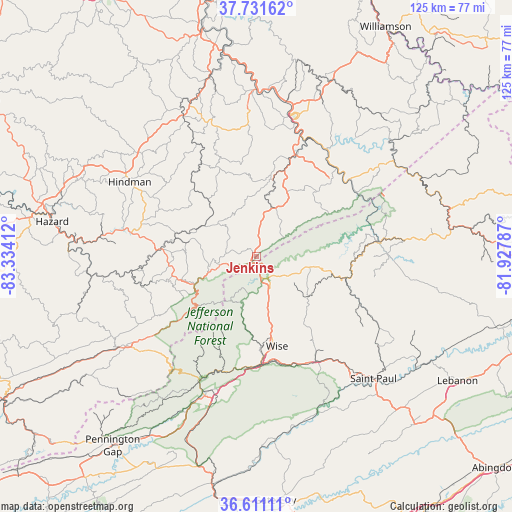
Jenkins GPS coordinates[2]
37° 10' 24.384" North, 82° 37' 51.564" West
| Map corner | latitude | longitude |
|---|---|---|
| Upper-left | 37.73162°, | -83.33412° |
| Center: | 37.17344°, | -82.63099° |
| Lower-right: | 36.61111°, | -81.92787° |
| Map W x H: | 124.6×124.6 km | = 77.4×77.4mi |
| max Lat: | 71.29058° ⇑65.4% North |
| Jenkins: | 37.17344° |
| min Lat: | ⇓34.6% South 19.06759° |
| min Long | Jenkins | max Long |
| -171.73463° | -82.63099° | -66.98998° |
| W 63.2%⇐ | ⇒36.8% E |
Elevation
Elevation of Jenkins is 474 m = 1555 ft, and this is 179.2 m = 588 ft above average elevation for this country.
| Max E: |
3189 m = 10463 ft | 12.8% |
| Jenkins | 474 m 1555 ft | |
| Avg. | 294.8 m = 967 ft | |
Min E: |
-60 m = -197 ft | 87.2% |
See also: United States elevation on elevation.city.
Geographical zone
Jenkins is located in North temperate zone (between Tropic of Cancer and the Arctic Circle). Distance of this Northern Tropic circle is 1527.4 km =949.1 mi to South.| Distance of | km | miles | from Jenkins |
|---|---|---|---|
| North Pole | 5873.8 | 3649.8 | to North |
| Arctic Circle | 3267.9 | 2030.6 | to North |
| Tropic Cancer | 1527.4 | 949.1 | to South |
| Equator | 4133.3 | 2568.3 | to South |


Nearby cities:
15 places around Jenkins: (largest is in red/bold)
• Appalachia
32.5 km =20.2 mi,  204°
204°
• Big Stone Gap
34 km =21.1 mi, 197°
• Clintwood
15.7 km =9.8 mi,  99°
99°
• Coeburn
29.5 km =18.3 mi,  149°
149°
• Elkhorn City
28.7 km =17.8 mi,  59°
59°
• Fleming-Neon
6.9 km =4.3 mi,  287°
287°
• Lynch
34.6 km =21.5 mi,  228°
228°
• McRoberts
5.2 km =3.2 mi,  316°
316°
• Norton
26.7 km =16.6 mi,  179°
179°
• Pippa Passes
28 km =17.4 mi,  309°
309°
• Pound
6.1 km =3.8 mi, 154°
• Riverview
29.6 km =18.4 mi, 153°
• Wheelwright
19.4 km =12.1 mi,  335°
335°
• Whitesburg
18.4 km =11.4 mi,  250°
250°
• Wise
22.5 km =14 mi,  167°
167°
Sources, notices
• [Note1] Compared only with cities in United States existing in our database
• [Src1] Map data: © OpenStreetMap contributors (CC-BY-SA)
• [Src2] Other city data from geonames.org with taken over terms of usage.
• [Src3] Geographical zone / Annual Mean Temperature by Robert A. Rohde @ Wikipedia
