Clintwood geodata
Clintwood (Virginia) is a seat of a second-order administrative division; located in United States in America/New_York (GMT-4) time zone. With population of 1,325 people, there are 14459 cities with bigger population in this country. Compared to other cities in United States, 65.5% of cities are located further ↑North; 64.1% of cities are located further ←West and 88.6% of cities have lower elevation than Clintwood. Note1


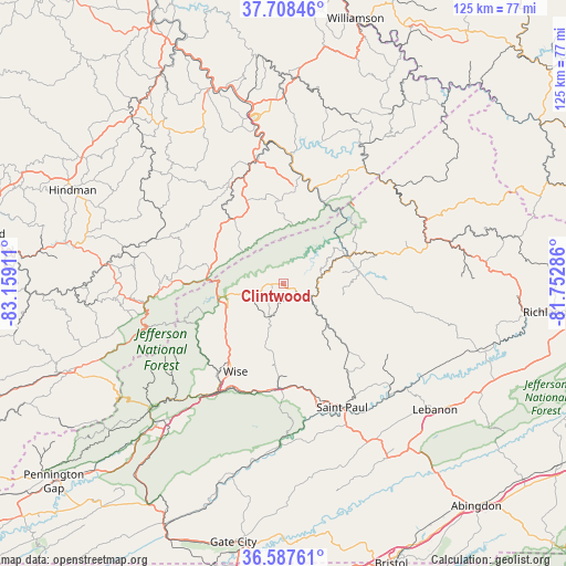
Clintwood GPS coordinates[2]
37° 9' 0.396" North, 82° 27' 21.528" West
| Map corner | latitude | longitude |
|---|---|---|
| Upper-left | 37.70846°, | -83.15911° |
| Center: | 37.15011°, | -82.45598° |
| Lower-right: | 36.58761°, | -81.75286° |
| Map W x H: | 124.6×124.6 km | = 77.4×77.4mi |
| max Lat: | 71.29058° ⇑65.5% North |
| Clintwood: | 37.15011° |
| min Lat: | ⇓34.5% South 19.06759° |
| min Long | Clintwood | max Long |
| -171.73463° | -82.45598° | -66.98998° |
| W 64.1%⇐ | ⇒35.9% E |
Elevation
Elevation of Clintwood is 538 m = 1765 ft, and this is 243.2 m = 798 ft above average elevation for this country.
| Max E: |
3189 m = 10463 ft | 11.4% |
| Clintwood | 538 m 1765 ft | |
| Avg. | 294.8 m = 967 ft | |
Min E: |
-60 m = -197 ft | 88.6% |
See also: United States elevation on elevation.city.
Geographical zone
Clintwood is located in North temperate zone (between Tropic of Cancer and the Arctic Circle). Distance of this Northern Tropic circle is 1524.8 km =947.5 mi to South.| Distance of | km | miles | from Clintwood |
|---|---|---|---|
| North Pole | 5876.4 | 3651.4 | to North |
| Arctic Circle | 3270.5 | 2032.2 | to North |
| Tropic Cancer | 1524.8 | 947.5 | to South |
| Equator | 4130.7 | 2566.7 | to South |


Nearby cities:
15 places around Clintwood: (largest is in red/bold)
• Castlewood
32.9 km =20.4 mi,  151°
151°
• Coeburn
22.9 km =14.2 mi,  181°
181°
• Dante
23.7 km =14.7 mi,  143°
143°
• Elkhorn City
19.5 km =12.1 mi,  28°
28°
• Fleming-Neon
22.6 km =14 mi,  281°
281°
• Grundy
34.7 km =21.6 mi,  65°
65°
• Jenkins
15.7 km =9.8 mi, 279°
• McRoberts
20.2 km =12.6 mi,  288°
288°
• Norton
28.6 km =17.8 mi,  212°
212°
• Pound
13.2 km =8.2 mi,  257°
257°
• Riverview
24 km =14.9 mi,  185°
185°
• Saint Paul
30.1 km =18.7 mi, 154°
• Wheelwright
31 km =19.3 mi,  310°
310°
• Whitesburg
33.1 km =20.6 mi, 263°
• Wise
22.1 km =13.7 mi, 208°
Sources, notices
• [Note1] Compared only with cities in United States existing in our database
• [Src1] Map data: © OpenStreetMap contributors (CC-BY-SA)
• [Src2] Other city data from geonames.org with taken over terms of usage.
• [Src3] Geographical zone / Annual Mean Temperature by Robert A. Rohde @ Wikipedia
