Heritage Creek geodata
Heritage Creek (Kentucky) is a populated place; located in United States in America/Kentucky/Louisville (GMT-4) time zone. With population of 1,076 people, there are 15807 cities with bigger population in this country. Compared to other cities in United States, 61% of cities are located further ↑North; 53.7% of cities are located further ←West and 61.7% of cities have higher elevation than Heritage Creek. Note1


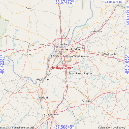
Heritage Creek GPS coordinates[2]
38° 7' 25.248" North, 85° 43' 10.848" West
| Map corner | latitude | longitude |
|---|---|---|
| Upper-left | 38.67472°, | -86.42281° |
| Center: | 38.12368°, | -85.71968° |
| Lower-right: | 37.56845°, | -85.01656° |
| Map W x H: | 123×123 km | = 76.4×76.4mi |
| max Lat: | 71.29058° ⇑61% North |
| Heritage Creek: | 38.12368° |
| min Lat: | ⇓39% South 19.06759° |
| min Long | Heritage Creek | max Long |
| -171.73463° | -85.71968° | -66.98998° |
| W 53.7%⇐ | ⇒46.3% E |
Elevation
Elevation of Heritage Creek is 146 m = 479 ft, and this is 148.8 m = 488 ft below average elevation for this country.
| Max E: |
3189 m = 10463 ft | 61.7% |
| Avg. | 294.8 m = 967 ft | |
| Heritage Creek | 146 m = 479 ft | |
Min E: |
-60 m = -197 ft | 38.3% |
See also: United States elevation on elevation.city.
Geographical zone
Heritage Creek is located in North temperate zone (between Tropic of Cancer and the Arctic Circle). Distance of this Northern Tropic circle is 1633 km =1014.7 mi to South.| Distance of | km | miles | from Heritage Creek |
|---|---|---|---|
| North Pole | 5768.1 | 3584.1 | to North |
| Arctic Circle | 3162.2 | 1964.9 | to North |
| Tropic Cancer | 1633 | 1014.7 | to South |
| Equator | 4239 | 2634 | to South |


Nearby cities:
15 places around Heritage Creek: (largest is in red/bold)
• Audubon Park
8.9 km =5.5 mi,  356°
356°
• Brooks
7 km =4.3 mi,  172°
172°
• Buechel
9.9 km =6.2 mi,  36°
36°
• Fairdale
4 km =2.5 mi,  238°
238°
• Hebron Estates
9.5 km =5.9 mi,  150°
150°
• Highview
8.6 km =5.3 mi,  75°
75°
• Hillview
6.7 km =4.2 mi, 153°
• Hollow Creek
8.9 km =5.5 mi,  68°
68°
• Hollyvilla
4 km =2.5 mi,  214°
214°
• Lynnview
6.1 km =3.8 mi,  8°
8°
• Newburg
6.6 km =4.1 mi,  52°
52°
• Okolona
3.4 km =2.1 mi,  55°
55°
• Pioneer Village
7.9 km =4.9 mi, 152°
• Watterson Park
8.3 km =5.2 mi,  22°
22°
• West Buechel
9.5 km =5.9 mi,  31°
31°
Sources, notices
• [Note1] Compared only with cities in United States existing in our database
• [Src1] Map data: © OpenStreetMap contributors (CC-BY-SA)
• [Src2] Other city data from geonames.org with taken over terms of usage.
• [Src3] Geographical zone / Annual Mean Temperature by Robert A. Rohde @ Wikipedia
