Owingsville geodata
Owingsville (Kentucky) is a seat of a second-order administrative division; located in United States in America/New_York (GMT-4) time zone. With population of 1,581 people, there are 13350 cities with bigger population in this country. Compared to other cities in United States, 60.9% of cities are located further ↑North; 59.9% of cities are located further ←West and 74.2% of cities have lower elevation than Owingsville. Note1


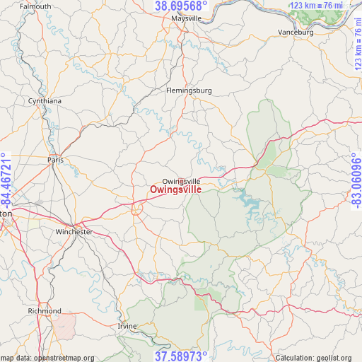
Owingsville GPS coordinates[2]
38° 8' 41.28" North, 83° 45' 50.688" West
| Map corner | latitude | longitude |
|---|---|---|
| Upper-left | 38.69568°, | -84.46721° |
| Center: | 38.1448°, | -83.76408° |
| Lower-right: | 37.58973°, | -83.06096° |
| Map W x H: | 123×123 km | = 76.4×76.4mi |
| max Lat: | 71.29058° ⇑60.9% North |
| Owingsville: | 38.1448° |
| min Lat: | ⇓39.1% South 19.06759° |
| min Long | Owingsville | max Long |
| -171.73463° | -83.76408° | -66.98998° |
| W 59.9%⇐ | ⇒40.1% E |
Elevation
Elevation of Owingsville is 308 m = 1010 ft, and this is 13.2 m = 43 ft above average elevation for this country.
| Max E: |
3189 m = 10463 ft | 25.8% |
| Owingsville | 308 m 1010 ft | |
| Avg. | 294.8 m = 967 ft | |
Min E: |
-60 m = -197 ft | 74.2% |
See also: United States elevation on elevation.city.
Geographical zone
Owingsville is located in North temperate zone (between Tropic of Cancer and the Arctic Circle). Distance of this Northern Tropic circle is 1635.4 km =1016.2 mi to South.| Distance of | km | miles | from Owingsville |
|---|---|---|---|
| North Pole | 5765.8 | 3582.7 | to North |
| Arctic Circle | 3159.9 | 1963.5 | to North |
| Tropic Cancer | 1635.4 | 1016.2 | to South |
| Equator | 4241.3 | 2635.4 | to South |


Nearby cities:
15 places around Owingsville: (largest is in red/bold)
• Camargo
19.9 km =12.4 mi,  212°
212°
• Campton
49.4 km =30.7 mi,  157°
157°
• Carlisle
29.6 km =18.4 mi,  308°
308°
• Clay City
34.5 km =21.4 mi,  203°
203°
• Flemingsburg
31 km =19.3 mi,  4°
4°
• Frenchburg
24.7 km =15.3 mi,  150°
150°
• Jeffersonville
20.2 km =12.6 mi, 199°
• Millersburg
37.8 km =23.5 mi,  297°
297°
• Morehead
29.3 km =18.2 mi,  81°
81°
• Mount Olivet
49.1 km =30.5 mi,  331°
331°
• Mount Sterling
18.5 km =11.5 mi,  237°
237°
• North Middletown
30.4 km =18.9 mi,  270°
270°
• Paris
43.3 km =26.9 mi,  279°
279°
• Stanton
34.3 km =21.3 mi,  193°
193°
• Winchester
40.2 km =25 mi, 244°
Sources, notices
• [Note1] Compared only with cities in United States existing in our database
• [Src1] Map data: © OpenStreetMap contributors (CC-BY-SA)
• [Src2] Other city data from geonames.org with taken over terms of usage.
• [Src3] Geographical zone / Annual Mean Temperature by Robert A. Rohde @ Wikipedia
