Clay City geodata
Clay City (Kentucky) is a populated place; located in United States in America/New_York (GMT-4) time zone. With population of 1,095 people, there are 15701 cities with bigger population in this country. Compared to other cities in United States, 62.4% of cities are located further ↑North; 59.5% of cities are located further ←West and 51.6% of cities have higher elevation than Clay City. Note1


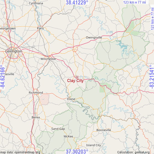
Clay City GPS coordinates[2]
37° 51' 33.3" North, 83° 55' 6.708" West
| Map corner | latitude | longitude |
|---|---|---|
| Upper-left | 38.41229°, | -84.62166° |
| Center: | 37.85925°, | -83.91853° |
| Lower-right: | 37.30203°, | -83.21541° |
| Map W x H: | 123.4×123.4 km | = 76.7×76.7mi |
| max Lat: | 71.29058° ⇑62.4% North |
| Clay City: | 37.85925° |
| min Lat: | ⇓37.6% South 19.06759° |
| min Long | Clay City | max Long |
| -171.73463° | -83.91853° | -66.98998° |
| W 59.5%⇐ | ⇒40.5% E |
Elevation
Elevation of Clay City is 192 m = 630 ft, and this is 102.8 m = 337 ft below average elevation for this country.
| Max E: |
3189 m = 10463 ft | 51.6% |
| Avg. | 294.8 m = 967 ft | |
| Clay City | 192 m = 630 ft | |
Min E: |
-60 m = -197 ft | 48.4% |
See also: United States elevation on elevation.city.
Geographical zone
Clay City is located in North temperate zone (between Tropic of Cancer and the Arctic Circle). Distance of this Northern Tropic circle is 1603.6 km =996.4 mi to South.| Distance of | km | miles | from Clay City |
|---|---|---|---|
| North Pole | 5797.5 | 3602.4 | to North |
| Arctic Circle | 3191.6 | 1983.2 | to North |
| Tropic Cancer | 1603.6 | 996.4 | to South |
| Equator | 4209.6 | 2615.7 | to South |


Nearby cities:
15 places around Clay City: (largest is in red/bold)
• Beattyville
37 km =23 mi,  149°
149°
• Berea
46.3 km =28.8 mi,  225°
225°
• Booneville
47.7 km =29.6 mi, 153°
• Camargo
15.3 km =9.5 mi,  10°
10°
• Campton
35.4 km =22 mi,  113°
113°
• Frenchburg
27.6 km =17.1 mi,  68°
68°
• Irvine
18.3 km =11.4 mi,  195°
195°
• Jeffersonville
14.4 km =8.9 mi,  27°
27°
• Mount Sterling
22 km =13.7 mi,  354°
354°
• North Middletown
36 km =22.4 mi,  332°
332°
• Owingsville
34.5 km =21.4 mi,  23°
23°
• Ravenna
19.7 km =12.2 mi,  188°
188°
• Richmond
35.3 km =21.9 mi,  249°
249°
• Stanton
5.5 km =3.4 mi, 105°
• Winchester
27.1 km =16.8 mi,  302°
302°
Sources, notices
• [Note1] Compared only with cities in United States existing in our database
• [Src1] Map data: © OpenStreetMap contributors (CC-BY-SA)
• [Src2] Other city data from geonames.org with taken over terms of usage.
• [Src3] Geographical zone / Annual Mean Temperature by Robert A. Rohde @ Wikipedia
