Chackbay geodata
Chackbay (Louisiana) is a populated place; located in United States in America/Chicago (GMT-5) time zone. With population of 5,177 people, there are 7025 cities with bigger population in this country. Compared to other cities in United States, 93.7% of cities are located further ↑North; 61.7% of cities are located further →East and 99.1% of cities have higher elevation than Chackbay. Note1


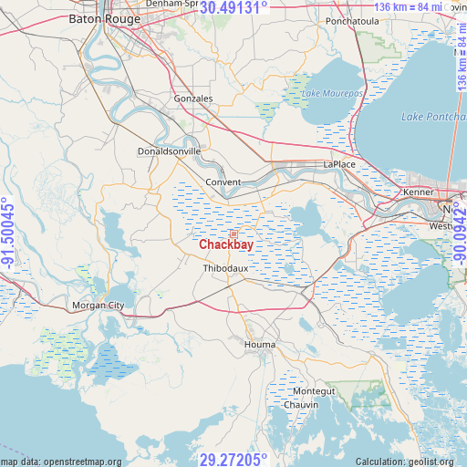
Chackbay GPS coordinates[2]
29° 53' 0.744" North, 90° 47' 50.352" West
| Map corner | latitude | longitude |
|---|---|---|
| Upper-left | 30.49131°, | -91.50045° |
| Center: | 29.88354°, | -90.79732° |
| Lower-right: | 29.27205°, | -90.0942° |
| Map W x H: | 135.6×135.6 km | = 84.3×84.3mi |
| max Lat: | 71.29058° ⇑93.7% North |
| Chackbay: | 29.88354° |
| min Lat: | ⇓6.3% South 19.06759° |
| min Long | Chackbay | max Long |
| -171.73463° | -90.79732° | -66.98998° |
| W 38.3%⇐ | ⇒61.7% E |
Elevation
Elevation of Chackbay is 3 m = 10 ft, and this is 291.8 m = 957 ft below average elevation for this country.
| Max E: |
3189 m = 10463 ft | 99.1% |
| Avg. | 294.8 m = 967 ft | |
| Chackbay | 3 m = 10 ft | |
Min E: |
-60 m = -197 ft | 0.9% |
See also: United States elevation on elevation.city.
Geographical zone
Chackbay is located in North temperate zone (between Tropic of Cancer and the Arctic Circle). Distance of this Northern Tropic circle is 716.8 km =445.4 mi to South.| Distance of | km | miles | from Chackbay |
|---|---|---|---|
| North Pole | 6684.3 | 4153.4 | to North |
| Arctic Circle | 4078.4 | 2534.2 | to North |
| Tropic Cancer | 716.8 | 445.4 | to South |
| Equator | 3322.7 | 2064.6 | to South |


Nearby cities:
15 places around Chackbay: (largest is in red/bold)
• Choctaw
11.4 km =7.1 mi,  115°
115°
• Convent
15.6 km =9.7 mi,  348°
348°
• Grand Point
20.2 km =12.6 mi,  12°
12°
• Gray
20.7 km =12.9 mi,  177°
177°
• Kraemer
9.8 km =6.1 mi,  100°
100°
• Labadieville
16.2 km =10.1 mi,  251°
251°
• Lutcher
19.9 km =12.4 mi,  28°
28°
• North Vacherie
15.4 km =9.6 mi,  35°
35°
• Paulina
17.8 km =11.1 mi, 27°
• Saint James
11.4 km =7.1 mi,  343°
343°
• Schriever
15.8 km =9.8 mi, 184°
• South Vacherie
10.6 km =6.6 mi,  62°
62°
• Supreme
17.9 km =11.1 mi,  261°
261°
• Thibodaux
10.1 km =6.3 mi,  194°
194°
• Welcome
20.7 km =12.9 mi, 340°
Sources, notices
• [Note1] Compared only with cities in United States existing in our database
• [Src1] Map data: © OpenStreetMap contributors (CC-BY-SA)
• [Src2] Other city data from geonames.org with taken over terms of usage.
• [Src3] Geographical zone / Annual Mean Temperature by Robert A. Rohde @ Wikipedia
