South Vacherie geodata
South Vacherie (Louisiana) is a populated place; located in United States in America/Chicago (GMT-5) time zone. With population of 3,642 people, there are 8669 cities with bigger population in this country. Compared to other cities in United States, 93.6% of cities are located further ↑North; 61.4% of cities are located further →East and 96.6% of cities have higher elevation than South Vacherie. Note1


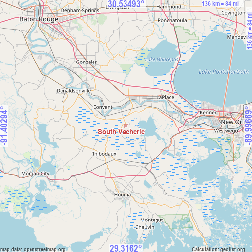
South Vacherie GPS coordinates[2]
29° 55' 38.748" North, 90° 41' 59.316" West
| Map corner | latitude | longitude |
|---|---|---|
| Upper-left | 30.53493°, | -91.40294° |
| Center: | 29.92743°, | -90.69981° |
| Lower-right: | 29.3162°, | -89.99669° |
| Map W x H: | 135.5×135.5 km | = 84.2×84.2mi |
| max Lat: | 71.29058° ⇑93.6% North |
| South Vacherie: | 29.92743° |
| min Lat: | ⇓6.4% South 19.06759° |
| min Long | South Vacherie | max Long |
| -171.73463° | -90.69981° | -66.98998° |
| W 38.6%⇐ | ⇒61.4% E |
Elevation
Elevation of South Vacherie is 7 m = 23 ft, and this is 287.8 m = 944 ft below average elevation for this country.
| Max E: |
3189 m = 10463 ft | 96.6% |
| Avg. | 294.8 m = 967 ft | |
| South Vacherie | 7 m = 23 ft | |
Min E: |
-60 m = -197 ft | 3.4% |
See also: United States elevation on elevation.city.
Geographical zone
South Vacherie is located in North temperate zone (between Tropic of Cancer and the Arctic Circle). Distance of this Northern Tropic circle is 721.7 km =448.4 mi to South.| Distance of | km | miles | from South Vacherie |
|---|---|---|---|
| North Pole | 6679.4 | 4150.4 | to North |
| Arctic Circle | 4073.6 | 2531.2 | to North |
| Tropic Cancer | 721.7 | 448.4 | to South |
| Equator | 3327.6 | 2067.7 | to South |


Nearby cities:
15 places around South Vacherie: (largest is in red/bold)
• Chackbay
10.6 km =6.6 mi,  242°
242°
• Choctaw
9.9 km =6.2 mi,  175°
175°
• Convent
16.3 km =10.1 mi,  309°
309°
• Edgard
18.6 km =11.6 mi,  46°
46°
• Garyville
16.3 km =10.1 mi,  28°
28°
• Gramercy
13.4 km =8.3 mi,  4°
4°
• Grand Point
15.8 km =9.8 mi,  340°
340°
• Kraemer
6.7 km =4.2 mi, 177°
• Lutcher
12.6 km =7.8 mi, 0°
• North Vacherie
7.7 km =4.8 mi,  355°
355°
• Paulina
11.1 km =6.9 mi,  353°
353°
• Reserve
20 km =12.4 mi, 45°
• Saint James
14.1 km =8.8 mi,  295°
295°
• Thibodaux
18.8 km =11.7 mi,  219°
219°
• Wallace
13.3 km =8.3 mi,  13°
13°
Sources, notices
• [Note1] Compared only with cities in United States existing in our database
• [Src1] Map data: © OpenStreetMap contributors (CC-BY-SA)
• [Src2] Other city data from geonames.org with taken over terms of usage.
• [Src3] Geographical zone / Annual Mean Temperature by Robert A. Rohde @ Wikipedia
