Gonzales geodata
Gonzales (Louisiana) is a populated place; located in United States in America/Chicago (GMT-5) time zone. With population of 10,678 people, there are 4275 cities with bigger population in this country. Compared to other cities in United States, 92.6% of cities are located further ↑North; 61.9% of cities are located further →East and 97.4% of cities have higher elevation than Gonzales. Note1


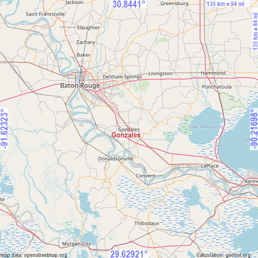
Gonzales GPS coordinates[2]
30° 14' 18.708" North, 90° 55' 12.36" West
| Map corner | latitude | longitude |
|---|---|---|
| Upper-left | 30.8441°, | -91.62323° |
| Center: | 30.23853°, | -90.9201° |
| Lower-right: | 29.62921°, | -90.21698° |
| Map W x H: | 135.1×135.1 km | = 83.9×83.9mi |
| max Lat: | 71.29058° ⇑92.6% North |
| Gonzales: | 30.23853° |
| min Lat: | ⇓7.4% South 19.06759° |
| min Long | Gonzales | max Long |
| -171.73463° | -90.9201° | -66.98998° |
| W 38.1%⇐ | ⇒61.9% E |
Elevation
Elevation of Gonzales is 6 m = 20 ft, and this is 288.8 m = 948 ft below average elevation for this country.
| Max E: |
3189 m = 10463 ft | 97.4% |
| Avg. | 294.8 m = 967 ft | |
| Gonzales | 6 m = 20 ft | |
Min E: |
-60 m = -197 ft | 2.6% |
See also: United States elevation on elevation.city.
Geographical zone
Gonzales is located in North temperate zone (between Tropic of Cancer and the Arctic Circle). Distance of this Northern Tropic circle is 756.3 km =469.9 mi to South.| Distance of | km | miles | from Gonzales |
|---|---|---|---|
| North Pole | 6644.9 | 4128.9 | to North |
| Arctic Circle | 4039 | 2509.7 | to North |
| Tropic Cancer | 756.3 | 469.9 | to South |
| Equator | 3362.2 | 2089.2 | to South |


Nearby cities:
15 places around Gonzales: (largest is in red/bold)
• Carville
17.1 km =10.6 mi,  262°
262°
• Donaldsonville
16.9 km =10.5 mi,  204°
204°
• French Settlement
13.5 km =8.4 mi,  61°
61°
• Lemannville
14.4 km =8.9 mi,  180°
180°
• Oak Hills Place
21 km =13 mi,  310°
310°
• Old Jefferson
18.5 km =11.5 mi,  329°
329°
• Port Vincent
12.6 km =7.8 mi,  32°
32°
• Prairieville
8.7 km =5.4 mi, 325°
• Saint Gabriel
17.3 km =10.7 mi,  277°
277°
• Shenandoah
19.7 km =12.2 mi,  336°
336°
• Sorrento
8.4 km =5.2 mi,  135°
135°
• Union
16.9 km =10.5 mi, 175°
• Village Saint George
19.7 km =12.2 mi, 314°
• Welcome
20.5 km =12.7 mi,  165°
165°
• White Castle
23.1 km =14.4 mi,  250°
250°
Sources, notices
• [Note1] Compared only with cities in United States existing in our database
• [Src1] Map data: © OpenStreetMap contributors (CC-BY-SA)
• [Src2] Other city data from geonames.org with taken over terms of usage.
• [Src3] Geographical zone / Annual Mean Temperature by Robert A. Rohde @ Wikipedia
