Village Saint George geodata
Village Saint George (Louisiana) is a populated place; located in United States in America/Chicago (GMT-5) time zone. With population of 7,104 people, there are 5761 cities with bigger population in this country. Compared to other cities in United States, 92.3% of cities are located further ↑North; 62.2% of cities are located further →East and 94.8% of cities have higher elevation than Village Saint George. Note1


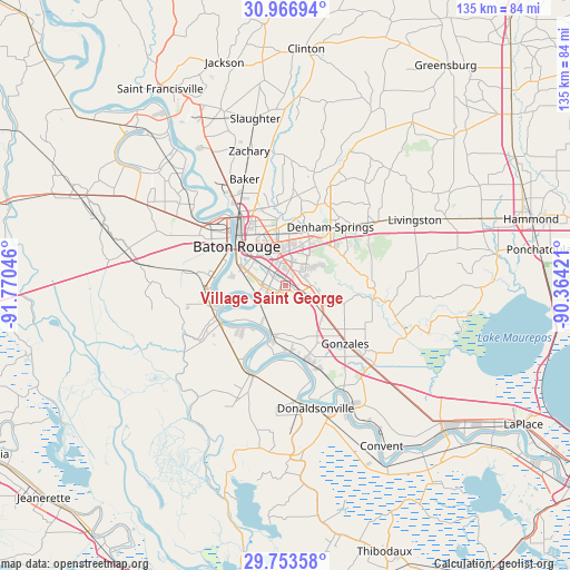
Village Saint George GPS coordinates[2]
30° 21' 43.704" North, 91° 4' 2.388" West
| Map corner | latitude | longitude |
|---|---|---|
| Upper-left | 30.96694°, | -91.77046° |
| Center: | 30.36214°, | -91.06733° |
| Lower-right: | 29.75358°, | -90.36421° |
| Map W x H: | 134.9×134.9 km | = 83.8×83.8mi |
| max Lat: | 71.29058° ⇑92.3% North |
| Village Saint George: | 30.36214° |
| min Lat: | ⇓7.7% South 19.06759° |
| min Long | Village Saint G | max Long |
| -171.73463° | -91.06733° | -66.98998° |
| W 37.8%⇐ | ⇒62.2% E |
Elevation
Elevation of Village Saint George is 9 m = 30 ft, and this is 285.8 m = 938 ft below average elevation for this country.
| Max E: |
3189 m = 10463 ft | 94.8% |
| Avg. | 294.8 m = 967 ft | |
| Village Saint George | 9 m = 30 ft | |
Min E: |
-60 m = -197 ft | 5.2% |
See also: United States elevation on elevation.city.
Geographical zone
Village Saint George is located in North temperate zone (between Tropic of Cancer and the Arctic Circle). Distance of this Northern Tropic circle is 770 km =478.5 mi to South.| Distance of | km | miles | from Village Saint George |
|---|---|---|---|
| North Pole | 6631.1 | 4120.4 | to North |
| Arctic Circle | 4025.2 | 2501.1 | to North |
| Tropic Cancer | 770 | 478.5 | to South |
| Equator | 3376 | 2097.7 | to South |


Nearby cities:
15 places around Village Saint George: (largest is in red/bold)
• Baton Rouge
14.6 km =9.1 mi,  308°
308°
• Carville
16.3 km =10.1 mi,  189°
189°
• Denham Springs
17.5 km =10.9 mi,  37°
37°
• Gardere
7.2 km =4.5 mi,  255°
255°
• Inniswold
5 km =3.1 mi,  341°
341°
• Merrydale
16 km =9.9 mi,  345°
345°
• Monticello
14.2 km =8.8 mi,  7°
7°
• Oak Hills Place
2 km =1.2 mi, 262°
• Old Jefferson
5.3 km =3.3 mi,  64°
64°
• Plaquemine
18 km =11.2 mi,  243°
243°
• Port Allen
17 km =10.6 mi, 306°
• Prairieville
11.3 km =7 mi,  125°
125°
• Saint Gabriel
12 km =7.5 mi, 194°
• Shenandoah
7.7 km =4.8 mi, 55°
• Westminster
6.1 km =3.8 mi, 341°
Sources, notices
• [Note1] Compared only with cities in United States existing in our database
• [Src1] Map data: © OpenStreetMap contributors (CC-BY-SA)
• [Src2] Other city data from geonames.org with taken over terms of usage.
• [Src3] Geographical zone / Annual Mean Temperature by Robert A. Rohde @ Wikipedia
