Houma geodata
Houma (Louisiana) is a seat of a second-order administrative division; located in United States in America/Chicago (GMT-5) time zone. With population of 34,287 people, there are 1435 cities with bigger population in this country. Compared to other cities in United States, 94.4% of cities are located further ↑North; 61.5% of cities are located further →East and 98.1% of cities have higher elevation than Houma. Note1


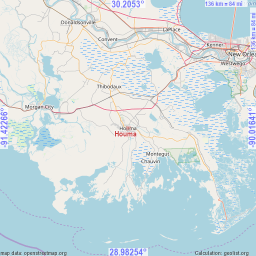
Houma GPS coordinates[2]
29° 35' 44.772" North, 90° 43' 10.308" West
| Map corner | latitude | longitude |
|---|---|---|
| Upper-left | 30.2053°, | -91.42266° |
| Center: | 29.59577°, | -90.71953° |
| Lower-right: | 28.98254°, | -90.01641° |
| Map W x H: | 136×136 km | = 84.5×84.5mi |
| max Lat: | 71.29058° ⇑94.4% North |
| Houma: | 29.59577° |
| min Lat: | ⇓5.6% South 19.06759° |
| min Long | Houma | max Long |
| -171.73463° | -90.71953° | -66.98998° |
| W 38.5%⇐ | ⇒61.5% E |
Elevation
Elevation of Houma is 5 m = 16 ft, and this is 289.8 m = 951 ft below average elevation for this country.
| Max E: |
3189 m = 10463 ft | 98.1% |
| Avg. | 294.8 m = 967 ft | |
| Houma | 5 m = 16 ft | |
Min E: |
-60 m = -197 ft | 1.9% |
See also: United States elevation on elevation.city.
Geographical zone
Houma is located in North temperate zone (between Tropic of Cancer and the Arctic Circle). Distance of this Northern Tropic circle is 684.8 km =425.5 mi to South.| Distance of | km | miles | from Houma |
|---|---|---|---|
| North Pole | 6716.3 | 4173.3 | to North |
| Arctic Circle | 4110.4 | 2554.1 | to North |
| Tropic Cancer | 684.8 | 425.5 | to South |
| Equator | 3290.7 | 2044.7 | to South |


Nearby cities:
15 places around Houma: (largest is in red/bold)
• Bayou Cane
4.4 km =2.7 mi,  315°
315°
• Bourg
12.3 km =7.6 mi,  112°
112°
• Chauvin
21.2 km =13.2 mi,  145°
145°
• Choctaw
27.2 km =16.9 mi,  5°
5°
• Dulac
23 km =14.3 mi,  178°
178°
• Gray
13.1 km =8.1 mi,  330°
330°
• Kraemer
30.2 km =18.8 mi,  4°
4°
• Lockport
18.3 km =11.4 mi,  72°
72°
• Lockport Heights
17.8 km =11.1 mi, 70°
• Mathews
19.5 km =12.1 mi,  58°
58°
• Montegut
20.7 km =12.9 mi,  130°
130°
• Presquille
7.9 km =4.9 mi,  116°
116°
• Raceland
18.7 km =11.6 mi,  38°
38°
• Schriever
18.5 km =11.5 mi, 331°
• Thibodaux
24.4 km =15.2 mi,  335°
335°
Sources, notices
• [Note1] Compared only with cities in United States existing in our database
• [Src1] Map data: © OpenStreetMap contributors (CC-BY-SA)
• [Src2] Other city data from geonames.org with taken over terms of usage.
• [Src3] Geographical zone / Annual Mean Temperature by Robert A. Rohde @ Wikipedia
