Lockport Heights geodata
Lockport Heights (Louisiana) is a populated place; located in United States in America/Chicago (GMT-5) time zone. With population of 1,286 people, there are 14657 cities with bigger population in this country. Compared to other cities in United States, 94.2% of cities are located further ↑North; 61% of cities are located further →East and 97.4% of cities have higher elevation than Lockport Heights. Note1


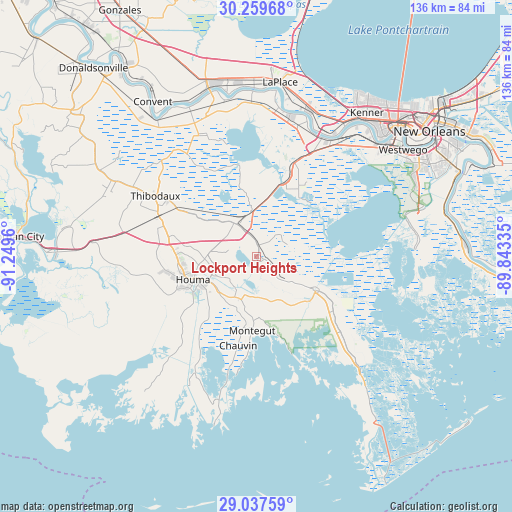
Lockport Heights GPS coordinates[2]
29° 39' 1.764" North, 90° 32' 47.292" West
| Map corner | latitude | longitude |
|---|---|---|
| Upper-left | 30.25968°, | -91.2496° |
| Center: | 29.65049°, | -90.54647° |
| Lower-right: | 29.03759°, | -89.84335° |
| Map W x H: | 135.9×135.9 km | = 84.4×84.4mi |
| max Lat: | 71.29058° ⇑94.2% North |
| Lockport Heights: | 29.65049° |
| min Lat: | ⇓5.8% South 19.06759° |
| min Long | Lockport Height | max Long |
| -171.73463° | -90.54647° | -66.98998° |
| W 39%⇐ | ⇒61% E |
Elevation
Elevation of Lockport Heights is 6 m = 20 ft, and this is 288.8 m = 948 ft below average elevation for this country.
| Max E: |
3189 m = 10463 ft | 97.4% |
| Avg. | 294.8 m = 967 ft | |
| Lockport Heights | 6 m = 20 ft | |
Min E: |
-60 m = -197 ft | 2.6% |
See also: United States elevation on elevation.city.
Geographical zone
Lockport Heights is located in North temperate zone (between Tropic of Cancer and the Arctic Circle). Distance of this Northern Tropic circle is 690.9 km =429.3 mi to South.| Distance of | km | miles | from Lockport Heights |
|---|---|---|---|
| North Pole | 6710.2 | 4169.5 | to North |
| Arctic Circle | 4104.3 | 2550.3 | to North |
| Tropic Cancer | 690.9 | 429.3 | to South |
| Equator | 3296.8 | 2048.5 | to South |


Nearby cities:
15 places around Lockport Heights: (largest is in red/bold)
• Bayou Cane
20 km =12.4 mi,  261°
261°
• Bayou Gauche
19.9 km =12.4 mi,  40°
40°
• Bourg
12.1 km =7.5 mi,  206°
206°
• Chauvin
24 km =14.9 mi,  191°
191°
• Choctaw
25.2 km =15.7 mi,  326°
326°
• Cut Off
23.4 km =14.5 mi,  120°
120°
• Des Allemands
20.5 km =12.7 mi,  19°
19°
• Gray
23.8 km =14.8 mi,  282°
282°
• Houma
17.8 km =11.1 mi,  250°
250°
• Larose
18.1 km =11.2 mi, 118°
• Lockport
0.9 km =0.6 mi,  125°
125°
• Mathews
4 km =2.5 mi,  359°
359°
• Montegut
19.6 km =12.2 mi,  182°
182°
• Presquille
13.6 km =8.5 mi,  225°
225°
• Raceland
9.9 km =6.2 mi, 329°
Sources, notices
• [Note1] Compared only with cities in United States existing in our database
• [Src1] Map data: © OpenStreetMap contributors (CC-BY-SA)
• [Src2] Other city data from geonames.org with taken over terms of usage.
• [Src3] Geographical zone / Annual Mean Temperature by Robert A. Rohde @ Wikipedia
