Kaplan geodata
Kaplan (Louisiana) is a populated place; located in United States in America/Chicago (GMT-5) time zone. With population of 4,617 people, there are 7525 cities with bigger population in this country. Compared to other cities in United States, 93.4% of cities are located further ↑North; 64.8% of cities are located further →East and 97.4% of cities have higher elevation than Kaplan. Note1


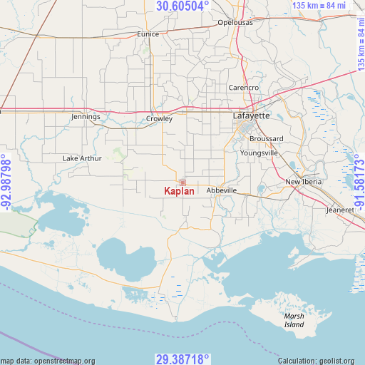
Kaplan GPS coordinates[2]
29° 59' 52.728" North, 92° 17' 5.46" West
| Map corner | latitude | longitude |
|---|---|---|
| Upper-left | 30.60504°, | -92.98798° |
| Center: | 29.99798°, | -92.28485° |
| Lower-right: | 29.38718°, | -91.58173° |
| Map W x H: | 135.4×135.4 km | = 84.1×84.1mi |
| max Lat: | 71.29058° ⇑93.4% North |
| Kaplan: | 29.99798° |
| min Lat: | ⇓6.6% South 19.06759° |
| min Long | Kaplan | max Long |
| -171.73463° | -92.28485° | -66.98998° |
| W 35.2%⇐ | ⇒64.8% E |
Elevation
Elevation of Kaplan is 6 m = 20 ft, and this is 288.8 m = 948 ft below average elevation for this country.
| Max E: |
3189 m = 10463 ft | 97.4% |
| Avg. | 294.8 m = 967 ft | |
| Kaplan | 6 m = 20 ft | |
Min E: |
-60 m = -197 ft | 2.6% |
See also: United States elevation on elevation.city.
Geographical zone
Kaplan is located in North temperate zone (between Tropic of Cancer and the Arctic Circle). Distance of this Northern Tropic circle is 729.5 km =453.3 mi to South.| Distance of | km | miles | from Kaplan |
|---|---|---|---|
| North Pole | 6671.6 | 4145.5 | to North |
| Arctic Circle | 4065.7 | 2526.3 | to North |
| Tropic Cancer | 729.5 | 453.3 | to South |
| Equator | 3335.5 | 2072.6 | to South |


Nearby cities:
15 places around Kaplan: (largest is in red/bold)
• Abbeville
14.7 km =9.1 mi,  100°
100°
• Crowley
25.5 km =15.8 mi,  340°
340°
• Delcambre
29.1 km =18.1 mi, 100°
• Duson
28.1 km =17.5 mi,  19°
19°
• Egan
34 km =21.1 mi,  321°
321°
• Erath
24.4 km =15.2 mi, 100°
• Estherwood
26.7 km =16.6 mi, 319°
• Gueydan
21.8 km =13.5 mi,  278°
278°
• Maurice
19.7 km =12.2 mi,  51°
51°
• Milton
23.2 km =14.4 mi,  59°
59°
• Morse
24.7 km =15.3 mi,  303°
303°
• Ossun
35.1 km =21.8 mi,  28°
28°
• Rayne
26.4 km =16.4 mi,  3°
3°
• Scott
32.2 km =20 mi, 34°
• Youngsville
30.5 km =19 mi,  68°
68°
Sources, notices
• [Note1] Compared only with cities in United States existing in our database
• [Src1] Map data: © OpenStreetMap contributors (CC-BY-SA)
• [Src2] Other city data from geonames.org with taken over terms of usage.
• [Src3] Geographical zone / Annual Mean Temperature by Robert A. Rohde @ Wikipedia
