Kenner geodata
Kenner (Louisiana) is a populated place; located in United States in America/Chicago (GMT-5) time zone. With population of 67,091 people, there are 627 cities with bigger population in this country. Compared to other cities in United States, 93.4% of cities are located further ↑North; 59.8% of cities are located further →East and 98.1% of cities have higher elevation than Kenner. Note1


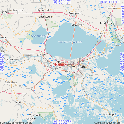
Kenner GPS coordinates[2]
29° 59' 38.724" North, 90° 14' 30.264" West
| Map corner | latitude | longitude |
|---|---|---|
| Upper-left | 30.60117°, | -90.94487° |
| Center: | 29.99409°, | -90.24174° |
| Lower-right: | 29.38327°, | -89.53862° |
| Map W x H: | 135.4×135.4 km | = 84.1×84.1mi |
| max Lat: | 71.29058° ⇑93.4% North |
| Kenner: | 29.99409° |
| min Lat: | ⇓6.6% South 19.06759° |
| min Long | Kenner | max Long |
| -171.73463° | -90.24174° | -66.98998° |
| W 40.2%⇐ | ⇒59.8% E |
Elevation
Elevation of Kenner is 5 m = 16 ft, and this is 289.8 m = 951 ft below average elevation for this country.
| Max E: |
3189 m = 10463 ft | 98.1% |
| Avg. | 294.8 m = 967 ft | |
| Kenner | 5 m = 16 ft | |
Min E: |
-60 m = -197 ft | 1.9% |
See also: Kenner elevation on elevation.city.
Geographical zone
Kenner is located in North temperate zone (between Tropic of Cancer and the Arctic Circle). Distance of this Northern Tropic circle is 729.1 km =453 mi to South.| Distance of | km | miles | from Kenner |
|---|---|---|---|
| North Pole | 6672 | 4145.8 | to North |
| Arctic Circle | 4066.1 | 2526.6 | to North |
| Tropic Cancer | 729.1 | 453 | to South |
| Equator | 3335 | 2072.3 | to South |


Nearby cities:
15 places around Kenner: (largest is in red/bold)
• Ama
7 km =4.3 mi,  228°
228°
• Avondale
9.7 km =6 mi,  157°
157°
• Bridge City
9.7 km =6 mi,  134°
134°
• Destrehan
12.2 km =7.6 mi,  242°
242°
• Elmwood
6.5 km =4 mi, 129°
• Harahan
7 km =4.3 mi,  148°
148°
• Jefferson
9.1 km =5.7 mi,  110°
110°
• Luling
13.8 km =8.6 mi, 240°
• Metairie
8.6 km =5.3 mi,  97°
97°
• Metairie Terrace
7.7 km =4.8 mi, 102°
• New Sarpy
14.4 km =8.9 mi,  262°
262°
• River Ridge
4.5 km =2.8 mi, 146°
• Saint Rose
9.4 km =5.8 mi, 236°
• Waggaman
8.9 km =5.5 mi, 160°
• Westwego
13.7 km =8.5 mi,  135°
135°
Sources, notices
• [Note1] Compared only with cities in United States existing in our database
• [Src1] Map data: © OpenStreetMap contributors (CC-BY-SA)
• [Src2] Other city data from geonames.org with taken over terms of usage.
• [Src3] Geographical zone / Annual Mean Temperature by Robert A. Rohde @ Wikipedia
