Krotz Springs geodata
Krotz Springs (Louisiana) is a populated place; located in United States in America/Chicago (GMT-5) time zone. With population of 1,203 people, there are 15117 cities with bigger population in this country. Compared to other cities in United States, 91.7% of cities are located further ↑North; 63.6% of cities are located further →East and 91.5% of cities have higher elevation than Krotz Springs. Note1


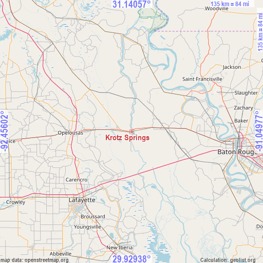
Krotz Springs GPS coordinates[2]
30° 32' 12.696" North, 91° 45' 10.404" West
| Map corner | latitude | longitude |
|---|---|---|
| Upper-left | 31.14057°, | -92.45602° |
| Center: | 30.53686°, | -91.75289° |
| Lower-right: | 29.92938°, | -91.04977° |
| Map W x H: | 134.7×134.7 km | = 83.7×83.7mi |
| max Lat: | 71.29058° ⇑91.7% North |
| Krotz Springs: | 30.53686° |
| min Lat: | ⇓8.3% South 19.06759° |
| min Long | Krotz Springs | max Long |
| -171.73463° | -91.75289° | -66.98998° |
| W 36.4%⇐ | ⇒63.6% E |
Elevation
Elevation of Krotz Springs is 13 m = 43 ft, and this is 281.8 m = 925 ft below average elevation for this country.
| Max E: |
3189 m = 10463 ft | 91.5% |
| Avg. | 294.8 m = 967 ft | |
| Krotz Springs | 13 m = 43 ft | |
Min E: |
-60 m = -197 ft | 8.5% |
See also: United States elevation on elevation.city.
Geographical zone
Krotz Springs is located in North temperate zone (between Tropic of Cancer and the Arctic Circle). Distance of this Northern Tropic circle is 789.5 km =490.6 mi to South.| Distance of | km | miles | from Krotz Springs |
|---|---|---|---|
| North Pole | 6611.7 | 4108.3 | to North |
| Arctic Circle | 4005.8 | 2489.1 | to North |
| Tropic Cancer | 789.5 | 490.6 | to South |
| Equator | 3395.4 | 2109.8 | to South |


Nearby cities:
15 places around Krotz Springs: (largest is in red/bold)
• Arnaudville
23.1 km =14.4 mi,  227°
227°
• Breaux Bridge
32.5 km =20.2 mi,  205°
205°
• Cecilia
24.2 km =15 mi,  203°
203°
• Fordoche
14.6 km =9.1 mi,  63°
63°
• Grand Coteau
31 km =19.3 mi,  245°
245°
• Henderson
25.1 km =15.6 mi,  188°
188°
• Leonville
22.8 km =14.2 mi, 251°
• Livonia
19 km =11.8 mi,  82°
82°
• Maringouin
22.9 km =14.2 mi,  102°
102°
• Melville
17.4 km =10.8 mi,  2°
2°
• Morganza
27.1 km =16.8 mi,  34°
34°
• Opelousas
31.5 km =19.6 mi,  269°
269°
• Port Barre
19.4 km =12.1 mi,  277°
277°
• Rosedale
30.7 km =19.1 mi,  110°
110°
• Washington
30.4 km =18.9 mi,  286°
286°
Sources, notices
• [Note1] Compared only with cities in United States existing in our database
• [Src1] Map data: © OpenStreetMap contributors (CC-BY-SA)
• [Src2] Other city data from geonames.org with taken over terms of usage.
• [Src3] Geographical zone / Annual Mean Temperature by Robert A. Rohde @ Wikipedia
