Natalbany geodata
Natalbany (Louisiana) is a populated place; located in United States in America/Chicago (GMT-5) time zone. With population of 2,984 people, there are 9663 cities with bigger population in this country. Compared to other cities in United States, 91.6% of cities are located further ↑North; 60.8% of cities are located further →East and 87.8% of cities have higher elevation than Natalbany. Note1


Natalbany GPS coordinates[2]
30° 32' 46.392" North, 90° 29' 10.284" West
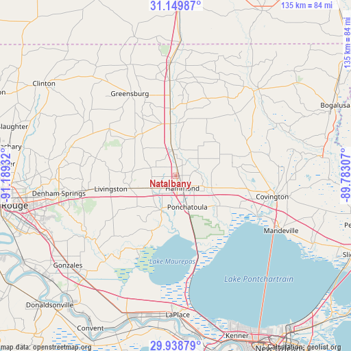
| Map corner | latitude | longitude |
|---|---|---|
| Upper-left | 31.14987°, | -91.18932° |
| Center: | 30.54622°, | -90.48619° |
| Lower-right: | 29.93879°, | -89.78307° |
| Map W x H: | 134.7×134.7 km | = 83.7×83.7mi |
| max Lat: | 71.29058° ⇑91.6% North |
| Natalbany: | 30.54622° |
| min Lat: | ⇓8.4% South 19.06759° |
| min Long | Natalbany | max Long |
| -171.73463° | -90.48619° | -66.98998° |
| W 39.2%⇐ | ⇒60.8% E |
Elevation
Elevation of Natalbany is 21 m = 69 ft, and this is 273.8 m = 898 ft below average elevation for this country.
| Max E: |
3189 m = 10463 ft | 87.8% |
| Avg. | 294.8 m = 967 ft | |
| Natalbany | 21 m = 69 ft | |
Min E: |
-60 m = -197 ft | 12.2% |
See also: United States elevation on elevation.city.
Geographical zone
Natalbany is located in North temperate zone (between Tropic of Cancer and the Arctic Circle). Distance of this Northern Tropic circle is 790.5 km =491.2 mi to South.| Distance of | km | miles | from Natalbany |
|---|---|---|---|
| North Pole | 6610.6 | 4107.6 | to North |
| Arctic Circle | 4004.8 | 2488.5 | to North |
| Tropic Cancer | 790.5 | 491.2 | to South |
| Equator | 3396.4 | 2110.4 | to South |


Nearby cities:
15 places around Natalbany: (largest is in red/bold)
• Albany
10.3 km =6.4 mi,  243°
243°
• Amite
20.2 km =12.6 mi,  353°
353°
• Covington
37.8 km =23.5 mi,  102°
102°
• Folsom
30.1 km =18.7 mi,  71°
71°
• Greensburg
36.3 km =22.6 mi,  330°
330°
• Hammond
5.1 km =3.2 mi,  154°
154°
• Independence
10.1 km =6.3 mi, 350°
• Killian
22.9 km =14.2 mi,  204°
204°
• Livingston
25.5 km =15.8 mi,  258°
258°
• Madisonville
35.3 km =21.9 mi,  116°
116°
• Ponchatoula
12.7 km =7.9 mi,  160°
160°
• Roseland
24.4 km =15.2 mi, 354°
• Tangipahoa
36.8 km =22.9 mi,  356°
356°
• Tickfaw
3.5 km =2.2 mi,  2°
2°
• Walker
36.5 km =22.7 mi, 259°
Sources, notices
• [Note1] Compared only with cities in United States existing in our database
• [Src1] Map data: © OpenStreetMap contributors (CC-BY-SA)
• [Src2] Other city data from geonames.org with taken over terms of usage.
• [Src3] Geographical zone / Annual Mean Temperature by Robert A. Rohde @ Wikipedia
