Slaughter geodata
Slaughter (Louisiana) is a populated place; located in United States in America/Chicago (GMT-5) time zone. With population of 963 people, there are 16543 cities with bigger population in this country. Compared to other cities in United States, 91.2% of cities are located further ↑North; 62.3% of cities are located further →East and 79.7% of cities have higher elevation than Slaughter. Note1


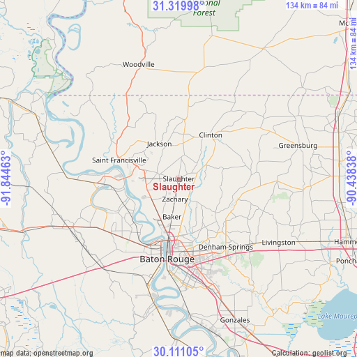
Slaughter GPS coordinates[2]
30° 43' 2.676" North, 91° 8' 29.4" West
| Map corner | latitude | longitude |
|---|---|---|
| Upper-left | 31.31998°, | -91.84463° |
| Center: | 30.71741°, | -91.1415° |
| Lower-right: | 30.11105°, | -90.43838° |
| Map W x H: | 134.4×134.4 km | = 83.5×83.5mi |
| max Lat: | 71.29058° ⇑91.2% North |
| Slaughter: | 30.71741° |
| min Lat: | ⇓8.8% South 19.06759° |
| min Long | Slaughter | max Long |
| -171.73463° | -91.1415° | -66.98998° |
| W 37.7%⇐ | ⇒62.3% E |
Elevation
Elevation of Slaughter is 48 m = 157 ft, and this is 246.8 m = 810 ft below average elevation for this country.
| Max E: |
3189 m = 10463 ft | 79.7% |
| Avg. | 294.8 m = 967 ft | |
| Slaughter | 48 m = 157 ft | |
Min E: |
-60 m = -197 ft | 20.3% |
See also: United States elevation on elevation.city.
Geographical zone
Slaughter is located in North temperate zone (between Tropic of Cancer and the Arctic Circle). Distance of this Northern Tropic circle is 809.5 km =503 mi to South.| Distance of | km | miles | from Slaughter |
|---|---|---|---|
| North Pole | 6591.6 | 4095.8 | to North |
| Arctic Circle | 3985.7 | 2476.6 | to North |
| Tropic Cancer | 809.5 | 503 | to South |
| Equator | 3415.5 | 2122.3 | to South |


Nearby cities:
15 places around Slaughter: (largest is in red/bold)
• Baker
14.6 km =9.1 mi,  190°
190°
• Brownsfield
19.1 km =11.9 mi,  174°
174°
• Central
20.7 km =12.9 mi,  151°
151°
• Clinton
20.4 km =12.7 mi,  36°
36°
• Greenwood
19.5 km =12.1 mi, 170°
• Jackson
15.2 km =9.4 mi,  331°
331°
• Merrydale
24.2 km =15 mi, 172°
• Monticello
26.9 km =16.7 mi,  160°
160°
• New Roads
28.2 km =17.5 mi,  266°
266°
• Port Allen
30.2 km =18.8 mi, 192°
• Saint Francisville
23.5 km =14.6 mi,  287°
287°
• Ventress
25.8 km =16 mi,  261°
261°
• Watson
23.9 km =14.9 mi,  131°
131°
• Wilson
22.7 km =14.1 mi,  6°
6°
• Zachary
7.8 km =4.8 mi, 190°
Sources, notices
• [Note1] Compared only with cities in United States existing in our database
• [Src1] Map data: © OpenStreetMap contributors (CC-BY-SA)
• [Src2] Other city data from geonames.org with taken over terms of usage.
• [Src3] Geographical zone / Annual Mean Temperature by Robert A. Rohde @ Wikipedia
