Sorrel geodata
Sorrel (Louisiana) is a populated place; located in United States in America/Chicago (GMT-5) time zone. With population of 766 people, there are 18081 cities with bigger population in this country. Compared to other cities in United States, 93.7% of cities are located further ↑North; 63.3% of cities are located further →East and 90.5% of cities have higher elevation than Sorrel. Note1


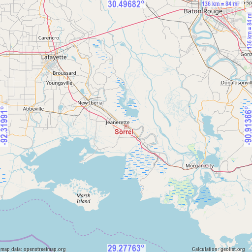
Sorrel GPS coordinates[2]
29° 53' 20.724" North, 91° 37' 0.408" West
| Map corner | latitude | longitude |
|---|---|---|
| Upper-left | 30.49682°, | -92.31991° |
| Center: | 29.88909°, | -91.61678° |
| Lower-right: | 29.27763°, | -90.91366° |
| Map W x H: | 135.6×135.6 km | = 84.3×84.3mi |
| max Lat: | 71.29058° ⇑93.7% North |
| Sorrel: | 29.88909° |
| min Lat: | ⇓6.3% South 19.06759° |
| min Long | Sorrel | max Long |
| -171.73463° | -91.61678° | -66.98998° |
| W 36.7%⇐ | ⇒63.3% E |
Elevation
Elevation of Sorrel is 15 m = 49 ft, and this is 279.8 m = 918 ft below average elevation for this country.
| Max E: |
3189 m = 10463 ft | 90.5% |
| Avg. | 294.8 m = 967 ft | |
| Sorrel | 15 m = 49 ft | |
Min E: |
-60 m = -197 ft | 9.5% |
See also: United States elevation on elevation.city.
Geographical zone
Sorrel is located in North temperate zone (between Tropic of Cancer and the Arctic Circle). Distance of this Northern Tropic circle is 717.4 km =445.8 mi to South.| Distance of | km | miles | from Sorrel |
|---|---|---|---|
| North Pole | 6683.7 | 4153.1 | to North |
| Arctic Circle | 4077.8 | 2533.8 | to North |
| Tropic Cancer | 717.4 | 445.8 | to South |
| Equator | 3323.4 | 2065.1 | to South |


Nearby cities:
15 places around Sorrel: (largest is in red/bold)
• Baldwin
9 km =5.6 mi,  129°
129°
• Bayou Vista
40.1 km =24.9 mi,  123°
123°
• Cade
35.5 km =22.1 mi,  308°
308°
• Catahoula
37.3 km =23.2 mi,  346°
346°
• Charenton
8.9 km =5.5 mi,  95°
95°
• Delcambre
36.4 km =22.6 mi,  280°
280°
• Erath
41.1 km =25.5 mi, 280°
• Franklin
15.2 km =9.4 mi, 132°
• Jeanerette
5.1 km =3.2 mi,  298°
298°
• Loreauville
21.9 km =13.6 mi,  328°
328°
• Lydia
16.5 km =10.3 mi, 283°
• New Iberia
23.2 km =14.4 mi, 303°
• Patterson
37.4 km =23.2 mi, 125°
• Pierre Part
40.7 km =25.3 mi,  78°
78°
• Saint Martinville
33.5 km =20.8 mi,  321°
321°
Sources, notices
• [Note1] Compared only with cities in United States existing in our database
• [Src1] Map data: © OpenStreetMap contributors (CC-BY-SA)
• [Src2] Other city data from geonames.org with taken over terms of usage.
• [Src3] Geographical zone / Annual Mean Temperature by Robert A. Rohde @ Wikipedia
