Loreauville geodata
Loreauville (Louisiana) is a populated place; located in United States in America/Chicago (GMT-5) time zone. With population of 899 people, there are 16988 cities with bigger population in this country. Compared to other cities in United States, 93.2% of cities are located further ↑North; 63.6% of cities are located further →East and 93.9% of cities have higher elevation than Loreauville. Note1


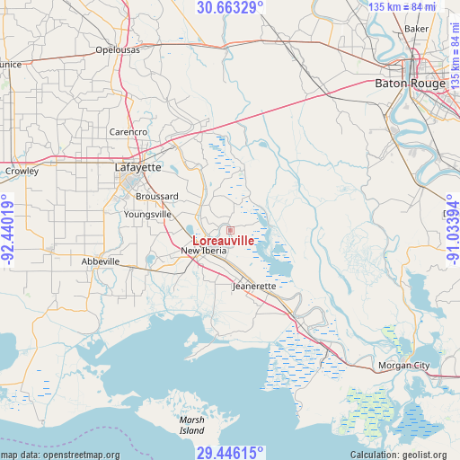
Loreauville GPS coordinates[2]
30° 3' 23.724" North, 91° 44' 13.416" West
| Map corner | latitude | longitude |
|---|---|---|
| Upper-left | 30.66329°, | -92.44019° |
| Center: | 30.05659°, | -91.73706° |
| Lower-right: | 29.44615°, | -91.03394° |
| Map W x H: | 135.3×135.3 km | = 84.1×84.1mi |
| max Lat: | 71.29058° ⇑93.2% North |
| Loreauville: | 30.05659° |
| min Lat: | ⇓6.8% South 19.06759° |
| min Long | Loreauville | max Long |
| -171.73463° | -91.73706° | -66.98998° |
| W 36.4%⇐ | ⇒63.6% E |
Elevation
Elevation of Loreauville is 10 m = 33 ft, and this is 284.8 m = 934 ft below average elevation for this country.
| Max E: |
3189 m = 10463 ft | 93.9% |
| Avg. | 294.8 m = 967 ft | |
| Loreauville | 10 m = 33 ft | |
Min E: |
-60 m = -197 ft | 6.1% |
See also: United States elevation on elevation.city.
Geographical zone
Loreauville is located in North temperate zone (between Tropic of Cancer and the Arctic Circle). Distance of this Northern Tropic circle is 736.1 km =457.4 mi to South.| Distance of | km | miles | from Loreauville |
|---|---|---|---|
| North Pole | 6665.1 | 4141.5 | to North |
| Arctic Circle | 4059.2 | 2522.3 | to North |
| Tropic Cancer | 736.1 | 457.4 | to South |
| Equator | 3342 | 2076.6 | to South |


Nearby cities:
15 places around Loreauville: (largest is in red/bold)
• Baldwin
30.6 km =19 mi,  142°
142°
• Breaux Bridge
28.7 km =17.8 mi,  327°
327°
• Broussard
23.8 km =14.8 mi,  295°
295°
• Cade
16.6 km =10.3 mi,  281°
281°
• Catahoula
17.8 km =11.1 mi,  8°
8°
• Charenton
28.2 km =17.5 mi,  133°
133°
• Delcambre
27.1 km =16.8 mi,  243°
243°
• Henderson
29 km =18 mi,  349°
349°
• Jeanerette
17.7 km =11 mi,  156°
156°
• Lydia
15.4 km =9.6 mi,  196°
196°
• New Iberia
9.8 km =6.1 mi,  233°
233°
• Parks
19.8 km =12.3 mi, 332°
• Saint Martinville
12 km =7.5 mi,  309°
309°
• Sorrel
21.9 km =13.6 mi,  148°
148°
• Youngsville
24.8 km =15.4 mi, 281°
Sources, notices
• [Note1] Compared only with cities in United States existing in our database
• [Src1] Map data: © OpenStreetMap contributors (CC-BY-SA)
• [Src2] Other city data from geonames.org with taken over terms of usage.
• [Src3] Geographical zone / Annual Mean Temperature by Robert A. Rohde @ Wikipedia
