Tallulah geodata
Tallulah (Louisiana) is a seat of a second-order administrative division; located in United States in America/Chicago (GMT-5) time zone. With population of 6,995 people, there are 5822 cities with bigger population in this country. Compared to other cities in United States, 87.5% of cities are located further ↑North; 62.4% of cities are located further →East and 84.4% of cities have higher elevation than Tallulah. Note1


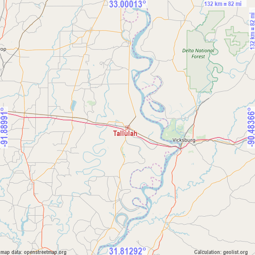
Tallulah GPS coordinates[2]
32° 24' 30.528" North, 91° 11' 12.408" West
| Map corner | latitude | longitude |
|---|---|---|
| Upper-left | 33.00013°, | -91.88991° |
| Center: | 32.40848°, | -91.18678° |
| Lower-right: | 31.81292°, | -90.48366° |
| Map W x H: | 132×132 km | = 82×82mi |
| max Lat: | 71.29058° ⇑87.5% North |
| Tallulah: | 32.40848° |
| min Lat: | ⇓12.5% South 19.06759° |
| min Long | Tallulah | max Long |
| -171.73463° | -91.18678° | -66.98998° |
| W 37.6%⇐ | ⇒62.4% E |
Elevation
Elevation of Tallulah is 30 m = 98 ft, and this is 264.8 m = 869 ft below average elevation for this country.
| Max E: |
3189 m = 10463 ft | 84.4% |
| Avg. | 294.8 m = 967 ft | |
| Tallulah | 30 m = 98 ft | |
Min E: |
-60 m = -197 ft | 15.6% |
See also: United States elevation on elevation.city.
Geographical zone
Tallulah is located in North temperate zone (between Tropic of Cancer and the Arctic Circle). Distance of this Northern Tropic circle is 997.6 km =619.9 mi to South.| Distance of | km | miles | from Tallulah |
|---|---|---|---|
| North Pole | 6403.6 | 3979 | to North |
| Arctic Circle | 3797.7 | 2359.8 | to North |
| Tropic Cancer | 997.6 | 619.9 | to South |
| Equator | 3603.5 | 2239.1 | to South |


Nearby cities:
15 places around Tallulah: (largest is in red/bold)
• Beechwood
35 km =21.7 mi,  104°
104°
• Delhi
29.3 km =18.2 mi,  280°
280°
• Edwards
55.3 km =34.4 mi, 99°
• Epps
34.9 km =21.7 mi,  308°
308°
• Lake Providence
44.1 km =27.4 mi,  1°
1°
• Mangham
56.3 km =35 mi,  258°
258°
• Mayersville
56.3 km =35 mi,  13°
13°
• Monticello
28.5 km =17.7 mi,  317°
317°
• Newellton
37.7 km =23.4 mi,  187°
187°
• Oak Grove
53.7 km =33.4 mi,  339°
339°
• Port Gibson
53.3 km =33.1 mi,  159°
159°
• Rayville
53.9 km =33.5 mi, 278°
• Richmond
2.3 km =1.4 mi,  169°
169°
• Saint Joseph
54.7 km =34 mi,  184°
184°
• Vicksburg
29.7 km =18.5 mi, 102°
Sources, notices
• [Note1] Compared only with cities in United States existing in our database
• [Src1] Map data: © OpenStreetMap contributors (CC-BY-SA)
• [Src2] Other city data from geonames.org with taken over terms of usage.
• [Src3] Geographical zone / Annual Mean Temperature by Robert A. Rohde @ Wikipedia
