Rayville geodata
Rayville (Louisiana) is a seat of a second-order administrative division; located in United States in America/Chicago (GMT-5) time zone. With population of 3,664 people, there are 8640 cities with bigger population in this country. Compared to other cities in United States, 87.2% of cities are located further ↑North; 63.6% of cities are located further →East and 85.8% of cities have higher elevation than Rayville. Note1


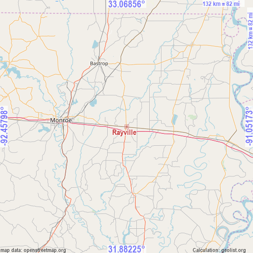
Rayville GPS coordinates[2]
32° 28' 38.496" North, 91° 45' 17.46" West
| Map corner | latitude | longitude |
|---|---|---|
| Upper-left | 33.06856°, | -92.45798° |
| Center: | 32.47736°, | -91.75485° |
| Lower-right: | 31.88225°, | -91.05173° |
| Map W x H: | 131.9×131.9 km | = 82×82mi |
| max Lat: | 71.29058° ⇑87.2% North |
| Rayville: | 32.47736° |
| min Lat: | ⇓12.8% South 19.06759° |
| min Long | Rayville | max Long |
| -171.73463° | -91.75485° | -66.98998° |
| W 36.4%⇐ | ⇒63.6% E |
Elevation
Elevation of Rayville is 26 m = 85 ft, and this is 268.8 m = 882 ft below average elevation for this country.
| Max E: |
3189 m = 10463 ft | 85.8% |
| Avg. | 294.8 m = 967 ft | |
| Rayville | 26 m = 85 ft | |
Min E: |
-60 m = -197 ft | 14.2% |
See also: United States elevation on elevation.city.
Geographical zone
Rayville is located in North temperate zone (between Tropic of Cancer and the Arctic Circle). Distance of this Northern Tropic circle is 1005.2 km =624.6 mi to South.| Distance of | km | miles | from Rayville |
|---|---|---|---|
| North Pole | 6395.9 | 3974.2 | to North |
| Arctic Circle | 3790 | 2355 | to North |
| Tropic Cancer | 1005.2 | 624.6 | to South |
| Equator | 3611.1 | 2243.8 | to South |


Nearby cities:
15 places around Rayville: (largest is in red/bold)
• Bastrop
36.5 km =22.7 mi,  336°
336°
• Bawcomville
38.7 km =24 mi,  268°
268°
• Brownsville
37.5 km =23.3 mi, 271°
• Delhi
24.6 km =15.3 mi,  95°
95°
• Epps
29.5 km =18.3 mi,  61°
61°
• Lakeshore
26.6 km =16.5 mi,  284°
284°
• Mangham
18.8 km =11.7 mi,  185°
185°
• Mer Rouge
33.3 km =20.7 mi,  353°
353°
• Monroe
34.4 km =21.4 mi, 275°
• Monticello
36.3 km =22.6 mi,  68°
68°
• Richwood
31.1 km =19.3 mi,  264°
264°
• Start
9.8 km =6.1 mi, 275°
• Swartz
23.9 km =14.9 mi,  295°
295°
• West Monroe
37.1 km =23.1 mi, 277°
• Winnsboro
35.1 km =21.8 mi,  174°
174°
Sources, notices
• [Note1] Compared only with cities in United States existing in our database
• [Src1] Map data: © OpenStreetMap contributors (CC-BY-SA)
• [Src2] Other city data from geonames.org with taken over terms of usage.
• [Src3] Geographical zone / Annual Mean Temperature by Robert A. Rohde @ Wikipedia
