Baton Rouge geodata
Baton Rouge (Louisiana) is a seat of a first-order administrative division; located in United States in America/Chicago (GMT-5) time zone. With population of 228,590 people, there are 106 cities with bigger population in this country. Compared to other cities in United States, 92% of cities are located further ↑North; 62.4% of cities are located further →East and 93.9% of cities have higher elevation than Baton Rouge. Note1


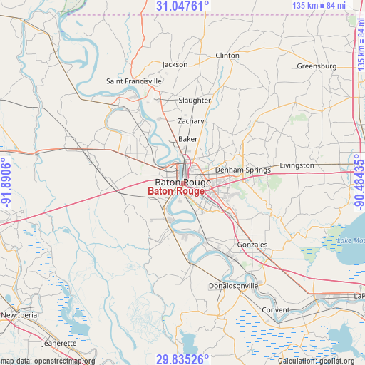
Baton Rouge GPS coordinates[2]
30° 26' 35.952" North, 91° 11' 14.892" West
| Map corner | latitude | longitude |
|---|---|---|
| Upper-left | 31.04761°, | -91.8906° |
| Center: | 30.44332°, | -91.18747° |
| Lower-right: | 29.83526°, | -90.48435° |
| Map W x H: | 134.8×134.8 km | = 83.8×83.8mi |
| max Lat: | 71.29058° ⇑92% North |
| Baton Rouge: | 30.44332° |
| min Lat: | ⇓8% South 19.06759° |
| min Long | Baton Rouge | max Long |
| -171.73463° | -91.18747° | -66.98998° |
| W 37.6%⇐ | ⇒62.4% E |
Elevation
Elevation of Baton Rouge is 10 m = 33 ft, and this is 284.8 m = 934 ft below average elevation for this country.
| Max E: |
3189 m = 10463 ft | 93.9% |
| Avg. | 294.8 m = 967 ft | |
| Baton Rouge | 10 m = 33 ft | |
Min E: |
-60 m = -197 ft | 6.1% |
See also: Baton Rouge elevation on elevation.city.
Geographical zone
Baton Rouge is located in North temperate zone (between Tropic of Cancer and the Arctic Circle). Distance of this Northern Tropic circle is 779.1 km =484.1 mi to South.| Distance of | km | miles | from Baton Rouge |
|---|---|---|---|
| North Pole | 6622.1 | 4114.8 | to North |
| Arctic Circle | 4016.2 | 2495.6 | to North |
| Tropic Cancer | 779.1 | 484.1 | to South |
| Equator | 3385 | 2103.3 | to South |


Nearby cities:
15 places around Baton Rouge: (largest is in red/bold)
• Addis
12.4 km =7.7 mi,  216°
216°
• Baker
16.2 km =10.1 mi,  6°
6°
• Brownsfield
13.1 km =8.1 mi,  29°
29°
• Brusly
8.4 km =5.2 mi,  229°
229°
• Gardere
11.8 km =7.3 mi,  157°
157°
• Greenwood
13.7 km =8.5 mi, 34°
• Inniswold
10.9 km =6.8 mi,  113°
113°
• Merrydale
9.9 km =6.2 mi,  49°
49°
• Monticello
14.2 km =8.8 mi,  69°
69°
• Oak Hills Place
13.3 km =8.3 mi,  134°
134°
• Old Jefferson
17.7 km =11 mi, 112°
• Plaquemine
17.6 km =10.9 mi,  194°
194°
• Port Allen
2.4 km =1.5 mi,  294°
294°
• Village Saint George
14.6 km =9.1 mi, 128°
• Westminster
10.1 km =6.3 mi, 108°
Sources, notices
• [Note1] Compared only with cities in United States existing in our database
• [Src1] Map data: © OpenStreetMap contributors (CC-BY-SA)
• [Src2] Other city data from geonames.org with taken over terms of usage.
• [Src3] Geographical zone / Annual Mean Temperature by Robert A. Rohde @ Wikipedia
