Ballenger Creek geodata
Ballenger Creek (Maryland) is a populated place; located in United States in America/New_York (GMT-4) time zone. With population of 18,274 people, there are 2744 cities with bigger population in this country. Compared to other cities in United States, 51.7% of cities are located further ↑North; 79.1% of cities are located further ←West and 71.8% of cities have higher elevation than Ballenger Creek. Note1


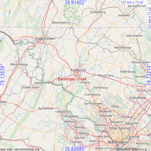
Ballenger Creek GPS coordinates[2]
39° 22' 21.36" North, 77° 26' 6.936" West
| Map corner | latitude | longitude |
|---|---|---|
| Upper-left | 39.91402°, | -78.13839° |
| Center: | 39.3726°, | -77.43526° |
| Lower-right: | 38.82695°, | -76.73214° |
| Map W x H: | 120.9×120.9 km | = 75.1×75.1mi |
| max Lat: | 71.29058° ⇑51.7% North |
| Ballenger Creek: | 39.3726° |
| min Lat: | ⇓48.3% South 19.06759° |
| min Long | Ballenger Creek | max Long |
| -171.73463° | -77.43526° | -66.98998° |
| W 79.1%⇐ | ⇒20.9% E |
Elevation
Elevation of Ballenger Creek is 90 m = 295 ft, and this is 204.8 m = 672 ft below average elevation for this country.
| Max E: |
3189 m = 10463 ft | 71.8% |
| Avg. | 294.8 m = 967 ft | |
| Ballenger Creek | 90 m = 295 ft | |
Min E: |
-60 m = -197 ft | 28.2% |
See also: United States elevation on elevation.city.
Geographical zone
Ballenger Creek is located in North temperate zone (between Tropic of Cancer and the Arctic Circle). Distance of this Northern Tropic circle is 1771.9 km =1101 mi to South.| Distance of | km | miles | from Ballenger Creek |
|---|---|---|---|
| North Pole | 5629.2 | 3497.8 | to North |
| Arctic Circle | 3023.4 | 1878.7 | to North |
| Tropic Cancer | 1771.9 | 1101 | to South |
| Equator | 4377.8 | 2720.2 | to South |


Nearby cities:
15 places around Ballenger Creek: (largest is in red/bold)
• Adamstown
7.6 km =4.7 mi,  206°
206°
• Bartonsville
7 km =4.3 mi,  71°
71°
• Braddock Heights
7.8 km =4.8 mi,  311°
311°
• Brunswick
17.8 km =11.1 mi,  248°
248°
• Buckeystown
4.2 km =2.6 mi,  175°
175°
• Clover Hill
9.3 km =5.8 mi,  3°
3°
• Frederick
5.1 km =3.2 mi,  24°
24°
• Green Valley
13.8 km =8.6 mi,  120°
120°
• Jefferson
8.4 km =5.2 mi,  261°
261°
• Middletown
12.3 km =7.6 mi, 310°
• New Market
14.3 km =8.9 mi,  85°
85°
• Point of Rocks
14 km =8.7 mi,  219°
219°
• Spring Ridge
7.8 km =4.8 mi, 65°
• Urbana
8.9 km =5.5 mi,  125°
125°
• Walkersville
14.5 km =9 mi,  29°
29°
Sources, notices
• [Note1] Compared only with cities in United States existing in our database
• [Src1] Map data: © OpenStreetMap contributors (CC-BY-SA)
• [Src2] Other city data from geonames.org with taken over terms of usage.
• [Src3] Geographical zone / Annual Mean Temperature by Robert A. Rohde @ Wikipedia
