Middletown geodata
Middletown (Maryland) is a populated place; located in United States in America/New_York (GMT-4) time zone. With population of 4,469 people, there are 7675 cities with bigger population in this country. Compared to other cities in United States, 51.2% of cities are located further ↑North; 78.8% of cities are located further ←West and 56.9% of cities have higher elevation than Middletown. Note1


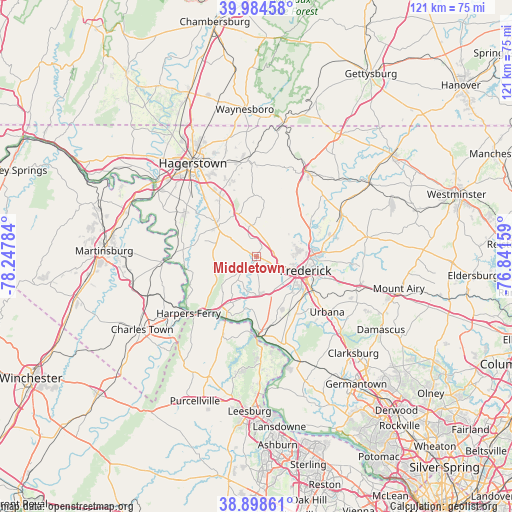
Middletown GPS coordinates[2]
39° 26' 37.356" North, 77° 32' 40.956" West
| Map corner | latitude | longitude |
|---|---|---|
| Upper-left | 39.98458°, | -78.24784° |
| Center: | 39.44371°, | -77.54471° |
| Lower-right: | 38.89861°, | -76.84159° |
| Map W x H: | 120.7×120.7 km | = 75×75mi |
| max Lat: | 71.29058° ⇑51.2% North |
| Middletown: | 39.44371° |
| min Lat: | ⇓48.8% South 19.06759° |
| min Long | Middletown | max Long |
| -171.73463° | -77.54471° | -66.98998° |
| W 78.8%⇐ | ⇒21.2% E |
Elevation
Elevation of Middletown is 171 m = 561 ft, and this is 123.8 m = 406 ft below average elevation for this country.
| Max E: |
3189 m = 10463 ft | 56.9% |
| Avg. | 294.8 m = 967 ft | |
| Middletown | 171 m = 561 ft | |
Min E: |
-60 m = -197 ft | 43.1% |
See also: United States elevation on elevation.city.
Geographical zone
Middletown is located in North temperate zone (between Tropic of Cancer and the Arctic Circle). Distance of this Northern Tropic circle is 1779.8 km =1105.9 mi to South.| Distance of | km | miles | from Middletown |
|---|---|---|---|
| North Pole | 5621.3 | 3492.9 | to North |
| Arctic Circle | 3015.4 | 1873.7 | to North |
| Tropic Cancer | 1779.8 | 1105.9 | to South |
| Equator | 4385.7 | 2725.1 | to South |


Nearby cities:
15 places around Middletown: (largest is in red/bold)
• Adamstown
15.9 km =9.9 mi,  157°
157°
• Ballenger Creek
12.3 km =7.6 mi,  130°
130°
• Bartonsville
17 km =10.6 mi,  109°
109°
• Boonsboro
11.6 km =7.2 mi,  306°
306°
• Braddock Heights
4.5 km =2.8 mi, 128°
• Brunswick
16.1 km =10 mi,  206°
206°
• Buckeystown
15.5 km =9.6 mi,  141°
141°
• Clover Hill
10 km =6.2 mi,  82°
82°
• Frederick
12 km =7.5 mi, 105°
• Jefferson
9.1 km =5.7 mi,  172°
172°
• Keedysville
14.1 km =8.8 mi,  289°
289°
• Mount Lena
14.7 km =9.1 mi,  330°
330°
• Myersville
7.1 km =4.4 mi,  344°
344°
• Spring Ridge
17.2 km =10.7 mi, 105°
• Walkersville
17.2 km =10.7 mi,  74°
74°
Sources, notices
• [Note1] Compared only with cities in United States existing in our database
• [Src1] Map data: © OpenStreetMap contributors (CC-BY-SA)
• [Src2] Other city data from geonames.org with taken over terms of usage.
• [Src3] Geographical zone / Annual Mean Temperature by Robert A. Rohde @ Wikipedia
