Crownsville geodata
Crownsville (Maryland) is a populated place; located in United States in America/New_York (GMT-4) time zone. With population of 1,757 people, there are 12716 cities with bigger population in this country. Compared to other cities in United States, 54.5% of cities are located further ↑North; 82.2% of cities are located further ←West and 81.6% of cities have higher elevation than Crownsville. Note1


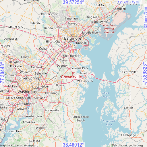
Crownsville GPS coordinates[2]
39° 1' 42.384" North, 76° 36' 4.86" West
| Map corner | latitude | longitude |
|---|---|---|
| Upper-left | 39.57254°, | -77.30448° |
| Center: | 39.02844°, | -76.60135° |
| Lower-right: | 38.48012°, | -75.89823° |
| Map W x H: | 121.5×121.5 km | = 75.5×75.5mi |
| max Lat: | 71.29058° ⇑54.5% North |
| Crownsville: | 39.02844° |
| min Lat: | ⇓45.5% South 19.06759° |
| min Long | Crownsville | max Long |
| -171.73463° | -76.60135° | -66.98998° |
| W 82.2%⇐ | ⇒17.8% E |
Elevation
Elevation of Crownsville is 40 m = 131 ft, and this is 254.8 m = 836 ft below average elevation for this country.
| Max E: |
3189 m = 10463 ft | 81.6% |
| Avg. | 294.8 m = 967 ft | |
| Crownsville | 40 m = 131 ft | |
Min E: |
-60 m = -197 ft | 18.4% |
See also: United States elevation on elevation.city.
Geographical zone
Crownsville is located in North temperate zone (between Tropic of Cancer and the Arctic Circle). Distance of this Northern Tropic circle is 1733.6 km =1077.2 mi to South.| Distance of | km | miles | from Crownsville |
|---|---|---|---|
| North Pole | 5667.5 | 3521.6 | to North |
| Arctic Circle | 3061.6 | 1902.4 | to North |
| Tropic Cancer | 1733.6 | 1077.2 | to South |
| Equator | 4339.6 | 2696.5 | to South |


Nearby cities:
15 places around Crownsville: (largest is in red/bold)
• Annapolis
10.9 km =6.8 mi,  120°
120°
• Arden on the Severn
4.6 km =2.9 mi,  24°
24°
• Arnold
8.5 km =5.3 mi,  87°
87°
• Crofton
8 km =5 mi,  248°
248°
• Edgewater
9.1 km =5.7 mi,  150°
150°
• Gambrills
7 km =4.3 mi,  307°
307°
• Herald Harbor
4 km =2.5 mi,  44°
44°
• Naval Academy
10.9 km =6.8 mi, 115°
• Odenton
10.5 km =6.5 mi, 305°
• Parole
8.2 km =5.1 mi,  131°
131°
• Pasadena
9.2 km =5.7 mi, 16°
• Riva
8.7 km =5.4 mi,  166°
166°
• Robinwood
11.1 km =6.9 mi,  137°
137°
• Severna Park
6.7 km =4.2 mi,  46°
46°
• South Gate
11.4 km =7.1 mi,  349°
349°
Sources, notices
• [Note1] Compared only with cities in United States existing in our database
• [Src1] Map data: © OpenStreetMap contributors (CC-BY-SA)
• [Src2] Other city data from geonames.org with taken over terms of usage.
• [Src3] Geographical zone / Annual Mean Temperature by Robert A. Rohde @ Wikipedia
