Annapolis geodata
Annapolis (Maryland) is a seat of a first-order administrative division; located in United States in America/New_York (GMT-4) time zone. With population of 39,474 people, there are 1229 cities with bigger population in this country. Compared to other cities in United States, 55.1% of cities are located further ↑North; 82.6% of cities are located further ←West and 89.5% of cities have higher elevation than Annapolis. Note1


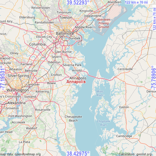
Annapolis GPS coordinates[2]
38° 58' 42.42" North, 76° 29' 31.848" West
| Map corner | latitude | longitude |
|---|---|---|
| Upper-left | 39.52293°, | -77.19531° |
| Center: | 38.97845°, | -76.49218° |
| Lower-right: | 38.42975°, | -75.78906° |
| Map W x H: | 121.6×121.6 km | = 75.6×75.6mi |
| max Lat: | 71.29058° ⇑55.1% North |
| Annapolis: | 38.97845° |
| min Lat: | ⇓44.9% South 19.06759° |
| min Long | Annapolis | max Long |
| -171.73463° | -76.49218° | -66.98998° |
| W 82.6%⇐ | ⇒17.4% E |
Elevation
Elevation of Annapolis is 17 m = 56 ft, and this is 277.8 m = 911 ft below average elevation for this country.
| Max E: |
3189 m = 10463 ft | 89.5% |
| Avg. | 294.8 m = 967 ft | |
| Annapolis | 17 m = 56 ft | |
Min E: |
-60 m = -197 ft | 10.5% |
See also: United States elevation on elevation.city.
Geographical zone
Annapolis is located in North temperate zone (between Tropic of Cancer and the Arctic Circle). Distance of this Northern Tropic circle is 1728.1 km =1073.8 mi to South.| Distance of | km | miles | from Annapolis |
|---|---|---|---|
| North Pole | 5673.1 | 3525.1 | to North |
| Arctic Circle | 3067.2 | 1905.9 | to North |
| Tropic Cancer | 1728.1 | 1073.8 | to South |
| Equator | 4334 | 2693 | to South |


Nearby cities:
15 places around Annapolis: (largest is in red/bold)
• Arden on the Severn
12.3 km =7.6 mi,  322°
322°
• Arnold
6 km =3.7 mi,  351°
351°
• Cape Saint Claire
8.3 km =5.2 mi,  29°
29°
• Crownsville
10.9 km =6.8 mi,  300°
300°
• Edgewater
5.5 km =3.4 mi,  244°
244°
• Herald Harbor
10.7 km =6.6 mi, 321°
• Hillsmere Shores
4.3 km =2.7 mi,  183°
183°
• Londontowne
7 km =4.3 mi,  224°
224°
• Mayo
10.2 km =6.3 mi,  189°
189°
• Naval Academy
0.9 km =0.6 mi, 25°
• Parole
3.3 km =2.1 mi,  272°
272°
• Riva
8 km =5 mi,  248°
248°
• Robinwood
3.3 km =2.1 mi, 215°
• Selby-on-the-Bay
7.4 km =4.6 mi,  200°
200°
• Severna Park
11.2 km =7 mi,  335°
335°
Sources, notices
• [Note1] Compared only with cities in United States existing in our database
• [Src1] Map data: © OpenStreetMap contributors (CC-BY-SA)
• [Src2] Other city data from geonames.org with taken over terms of usage.
• [Src3] Geographical zone / Annual Mean Temperature by Robert A. Rohde @ Wikipedia
