Kettering geodata
Kettering (Maryland) is a populated place; located in United States in America/New_York (GMT-4) time zone. With population of 12,790 people, there are 3715 cities with bigger population in this country. Compared to other cities in United States, 55.9% of cities are located further ↑North; 81.4% of cities are located further ←West and 79.9% of cities have higher elevation than Kettering. Note1


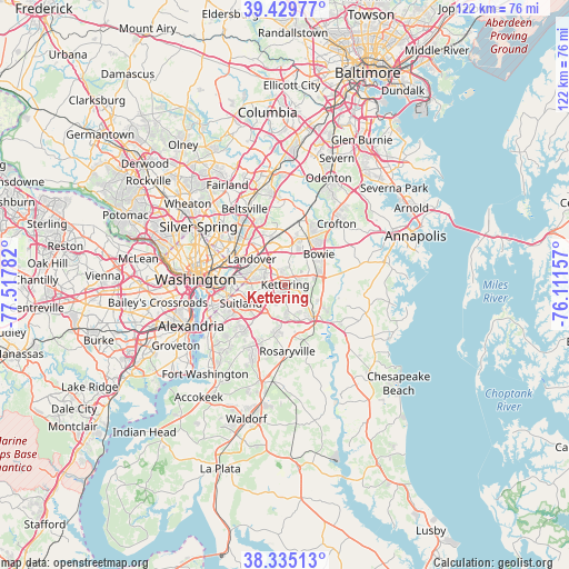
Kettering GPS coordinates[2]
38° 53' 4.416" North, 76° 48' 52.884" West
| Map corner | latitude | longitude |
|---|---|---|
| Upper-left | 39.42977°, | -77.51782° |
| Center: | 38.88456°, | -76.81469° |
| Lower-right: | 38.33513°, | -76.11157° |
| Map W x H: | 121.7×121.7 km | = 75.6×75.6mi |
| max Lat: | 71.29058° ⇑55.9% North |
| Kettering: | 38.88456° |
| min Lat: | ⇓44.1% South 19.06759° |
| min Long | Kettering | max Long |
| -171.73463° | -76.81469° | -66.98998° |
| W 81.4%⇐ | ⇒18.6% E |
Elevation
Elevation of Kettering is 47 m = 154 ft, and this is 247.8 m = 813 ft below average elevation for this country.
| Max E: |
3189 m = 10463 ft | 79.9% |
| Avg. | 294.8 m = 967 ft | |
| Kettering | 47 m = 154 ft | |
Min E: |
-60 m = -197 ft | 20.1% |
See also: United States elevation on elevation.city.
Geographical zone
Kettering is located in North temperate zone (between Tropic of Cancer and the Arctic Circle). Distance of this Northern Tropic circle is 1717.6 km =1067.3 mi to South.| Distance of | km | miles | from Kettering |
|---|---|---|---|
| North Pole | 5683.5 | 3531.6 | to North |
| Arctic Circle | 3077.6 | 1912.3 | to North |
| Tropic Cancer | 1717.6 | 1067.3 | to South |
| Equator | 4323.6 | 2686.6 | to South |


Nearby cities:
15 places around Kettering: (largest is in red/bold)
• Brock Hall
6 km =3.7 mi,  129°
129°
• District Heights
7.1 km =4.4 mi,  245°
245°
• Forestville
6.8 km =4.2 mi,  229°
229°
• Glenarden
6.4 km =4 mi,  320°
320°
• Lake Arbor
2.9 km =1.8 mi,  333°
333°
• Largo
2 km =1.2 mi, 317°
• Marlboro Village
7.2 km =4.5 mi,  147°
147°
• Mitchellville
7.7 km =4.8 mi,  54°
54°
• Peppermill Village
6.3 km =3.9 mi,  280°
280°
• Seat Pleasant
8.1 km =5 mi, 279°
• Springdale
6.3 km =3.9 mi,  340°
340°
• Summerfield
5.1 km =3.2 mi,  295°
295°
• Walker Mill
6.5 km =4 mi,  260°
260°
• Westphalia
4.4 km =2.7 mi,  175°
175°
• Woodmore
4.2 km =2.6 mi,  13°
13°
Sources, notices
• [Note1] Compared only with cities in United States existing in our database
• [Src1] Map data: © OpenStreetMap contributors (CC-BY-SA)
• [Src2] Other city data from geonames.org with taken over terms of usage.
• [Src3] Geographical zone / Annual Mean Temperature by Robert A. Rohde @ Wikipedia
