Mitchellville geodata
Mitchellville (Maryland) is a populated place; located in United States in America/New_York (GMT-4) time zone. With population of 10,967 people, there are 4184 cities with bigger population in this country. Compared to other cities in United States, 55.6% of cities are located further ↑North; 81.7% of cities are located further ←West and 82.6% of cities have higher elevation than Mitchellville. Note1


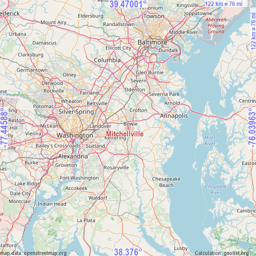
Mitchellville GPS coordinates[2]
38° 55' 30.396" North, 76° 44' 33.9" West
| Map corner | latitude | longitude |
|---|---|---|
| Upper-left | 39.47001°, | -77.44588° |
| Center: | 38.92511°, | -76.74275° |
| Lower-right: | 38.376°, | -76.03963° |
| Map W x H: | 121.6×121.6 km | = 75.6×75.6mi |
| max Lat: | 71.29058° ⇑55.6% North |
| Mitchellville: | 38.92511° |
| min Lat: | ⇓44.4% South 19.06759° |
| min Long | Mitchellville | max Long |
| -171.73463° | -76.74275° | -66.98998° |
| W 81.7%⇐ | ⇒18.3% E |
Elevation
Elevation of Mitchellville is 36 m = 118 ft, and this is 258.8 m = 849 ft below average elevation for this country.
| Max E: |
3189 m = 10463 ft | 82.6% |
| Avg. | 294.8 m = 967 ft | |
| Mitchellville | 36 m = 118 ft | |
Min E: |
-60 m = -197 ft | 17.4% |
See also: United States elevation on elevation.city.
Geographical zone
Mitchellville is located in North temperate zone (between Tropic of Cancer and the Arctic Circle). Distance of this Northern Tropic circle is 1722.1 km =1070.1 mi to South.| Distance of | km | miles | from Mitchellville |
|---|---|---|---|
| North Pole | 5679 | 3528.8 | to North |
| Arctic Circle | 3073.1 | 1909.5 | to North |
| Tropic Cancer | 1722.1 | 1070.1 | to South |
| Equator | 4328.1 | 2689.4 | to South |


Nearby cities:
15 places around Mitchellville: (largest is in red/bold)
• Bowie
2.2 km =1.4 mi,  28°
28°
• Brock Hall
8.5 km =5.3 mi,  190°
190°
• Crofton
9.8 km =6.1 mi, 29°
• Davidsonville
9.9 km =6.2 mi,  91°
91°
• Fairwood
4.6 km =2.9 mi,  319°
319°
• Glenarden
10.3 km =6.4 mi,  272°
272°
• Glenn Dale
9.7 km =6 mi, 315°
• Kettering
7.7 km =4.8 mi,  234°
234°
• Lake Arbor
7.8 km =4.8 mi,  255°
255°
• Largo
8.2 km =5.1 mi,  248°
248°
• Marlboro Meadows
10.2 km =6.3 mi,  166°
166°
• Queen Anne
6.3 km =3.9 mi,  117°
117°
• Seabrook
10.2 km =6.3 mi,  298°
298°
• Springdale
8.4 km =5.2 mi,  279°
279°
• Woodmore
5.2 km =3.2 mi, 265°
Sources, notices
• [Note1] Compared only with cities in United States existing in our database
• [Src1] Map data: © OpenStreetMap contributors (CC-BY-SA)
• [Src2] Other city data from geonames.org with taken over terms of usage.
• [Src3] Geographical zone / Annual Mean Temperature by Robert A. Rohde @ Wikipedia
