Kingsville geodata
Kingsville (Maryland) is a populated place; located in United States in America/New_York (GMT-4) time zone. With population of 4,318 people, there are 7847 cities with bigger population in this country. Compared to other cities in United States, 51.2% of cities are located further ↑North; 82.9% of cities are located further ←West and 73% of cities have higher elevation than Kingsville. Note1


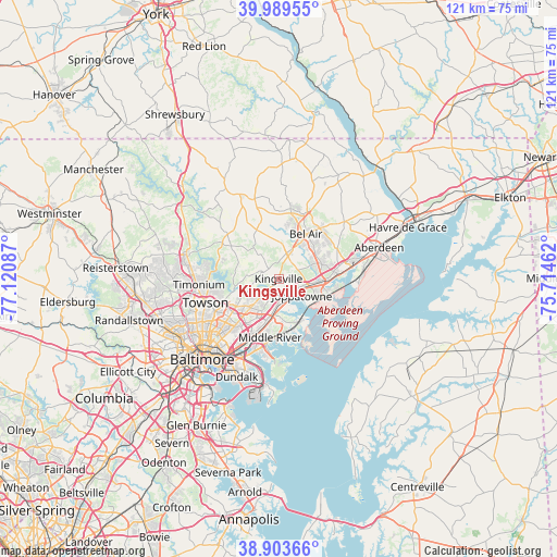
Kingsville GPS coordinates[2]
39° 26' 55.392" North, 76° 25' 3.864" West
| Map corner | latitude | longitude |
|---|---|---|
| Upper-left | 39.98955°, | -77.12087° |
| Center: | 39.44872°, | -76.41774° |
| Lower-right: | 38.90366°, | -75.71462° |
| Map W x H: | 120.7×120.7 km | = 75×75mi |
| max Lat: | 71.29058° ⇑51.2% North |
| Kingsville: | 39.44872° |
| min Lat: | ⇓48.8% South 19.06759° |
| min Long | Kingsville | max Long |
| -171.73463° | -76.41774° | -66.98998° |
| W 82.9%⇐ | ⇒17.1% E |
Elevation
Elevation of Kingsville is 83 m = 272 ft, and this is 211.8 m = 695 ft below average elevation for this country.
| Max E: |
3189 m = 10463 ft | 73% |
| Avg. | 294.8 m = 967 ft | |
| Kingsville | 83 m = 272 ft | |
Min E: |
-60 m = -197 ft | 27% |
See also: United States elevation on elevation.city.
Geographical zone
Kingsville is located in North temperate zone (between Tropic of Cancer and the Arctic Circle). Distance of this Northern Tropic circle is 1780.4 km =1106.3 mi to South.| Distance of | km | miles | from Kingsville |
|---|---|---|---|
| North Pole | 5620.8 | 3492.6 | to North |
| Arctic Circle | 3014.9 | 1873.4 | to North |
| Tropic Cancer | 1780.4 | 1106.3 | to South |
| Equator | 4386.3 | 2725.5 | to South |


Nearby cities:
15 places around Kingsville: (largest is in red/bold)
• Bel Air
11.4 km =7.1 mi,  31°
31°
• Bel Air North
12.3 km =7.6 mi,  18°
18°
• Bel Air South
10.5 km =6.5 mi,  53°
53°
• Bowleys Quarters
12.8 km =8 mi,  169°
169°
• Carney
10.9 km =6.8 mi,  236°
236°
• Edgewood
11.1 km =6.9 mi,  107°
107°
• Fallston
7.3 km =4.5 mi,  4°
4°
• Joppatowne
5.5 km =3.4 mi,  79°
79°
• Middle River
12.9 km =8 mi,  188°
188°
• North Bel Air
11.5 km =7.1 mi, 28°
• Overlea
13 km =8.1 mi,  222°
222°
• Perry Hall
5.6 km =3.5 mi, 224°
• Pleasant Hills
4 km =2.5 mi, 30°
• South Bel Air
11.6 km =7.2 mi,  36°
36°
• White Marsh
7.3 km =4.5 mi, 189°
Sources, notices
• [Note1] Compared only with cities in United States existing in our database
• [Src1] Map data: © OpenStreetMap contributors (CC-BY-SA)
• [Src2] Other city data from geonames.org with taken over terms of usage.
• [Src3] Geographical zone / Annual Mean Temperature by Robert A. Rohde @ Wikipedia
