Bel Air South geodata
Bel Air South (Maryland) is a populated place; located in United States in America/New_York (GMT-4) time zone. With population of 47,709 people, there are 1007 cities with bigger population in this country. Compared to other cities in United States, 50.8% of cities are located further ↑North; 83.1% of cities are located further ←West and 70.8% of cities have higher elevation than Bel Air South. Note1


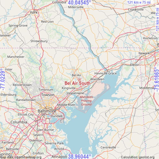
Bel Air South GPS coordinates[2]
39° 30' 18.216" North, 76° 19' 11.172" West
| Map corner | latitude | longitude |
|---|---|---|
| Upper-left | 40.04545°, | -77.0229° |
| Center: | 39.50506°, | -76.31977° |
| Lower-right: | 38.96044°, | -75.61665° |
| Map W x H: | 120.6×120.6 km | = 74.9×74.9mi |
| max Lat: | 71.29058° ⇑50.8% North |
| Bel Air South: | 39.50506° |
| min Lat: | ⇓49.2% South 19.06759° |
| min Long | Bel Air South | max Long |
| -171.73463° | -76.31977° | -66.98998° |
| W 83.1%⇐ | ⇒16.9% E |
Elevation
Elevation of Bel Air South is 96 m = 315 ft, and this is 198.8 m = 652 ft below average elevation for this country.
| Max E: |
3189 m = 10463 ft | 70.8% |
| Avg. | 294.8 m = 967 ft | |
| Bel Air South | 96 m = 315 ft | |
Min E: |
-60 m = -197 ft | 29.2% |
See also: Bel Air South elevation on elevation.city.
Geographical zone
Bel Air South is located in North temperate zone (between Tropic of Cancer and the Arctic Circle). Distance of this Northern Tropic circle is 1786.6 km =1110.1 mi to South.| Distance of | km | miles | from Bel Air South |
|---|---|---|---|
| North Pole | 5614.5 | 3488.7 | to North |
| Arctic Circle | 3008.6 | 1869.5 | to North |
| Tropic Cancer | 1786.6 | 1110.1 | to South |
| Equator | 4392.6 | 2729.4 | to South |


Nearby cities:
15 places around Bel Air South: (largest is in red/bold)
• Aberdeen
13.4 km =8.3 mi,  87°
87°
• Aberdeen Proving Ground
16.8 km =10.4 mi,  104°
104°
• Bel Air
4.2 km =2.6 mi,  324°
324°
• Bel Air North
7.1 km =4.4 mi, 320°
• Edgewood
9.8 km =6.1 mi,  167°
167°
• Fallston
7.9 km =4.9 mi,  277°
277°
• Joppatowne
6.1 km =3.8 mi,  210°
210°
• Kingsville
10.5 km =6.5 mi,  233°
233°
• North Bel Air
4.9 km =3 mi, 322°
• Perry Hall
16.1 km =10 mi, 230°
• Perryman
10.7 km =6.6 mi,  111°
111°
• Pleasant Hills
7 km =4.3 mi,  246°
246°
• Riverside
7.6 km =4.7 mi,  117°
117°
• South Bel Air
3.5 km =2.2 mi,  334°
334°
• White Marsh
16.6 km =10.3 mi,  215°
215°
Sources, notices
• [Note1] Compared only with cities in United States existing in our database
• [Src1] Map data: © OpenStreetMap contributors (CC-BY-SA)
• [Src2] Other city data from geonames.org with taken over terms of usage.
• [Src3] Geographical zone / Annual Mean Temperature by Robert A. Rohde @ Wikipedia
