Pylesville geodata
Pylesville (Maryland) is a populated place; located in United States in America/New_York (GMT-4) time zone. With population of 693 people, there are 18745 cities with bigger population in this country. Compared to other cities in United States, 50.6% of cities are located further ↓South; 83% of cities are located further ←West and 68% of cities have higher elevation than Pylesville. Note1


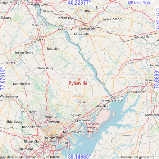
Pylesville GPS coordinates[2]
39° 41' 23.388" North, 76° 22' 22.872" West
| Map corner | latitude | longitude |
|---|---|---|
| Upper-left | 40.22877°, | -77.07615° |
| Center: | 39.68983°, | -76.37302° |
| Lower-right: | 39.14665°, | -75.6699° |
| Map W x H: | 120.3×120.3 km | = 74.8×74.8mi |
| max Lat: | 71.29058° ⇑49.4% North |
| Pylesville: | 39.68983° |
| min Lat: | ⇓50.6% South 19.06759° |
| min Long | Pylesville | max Long |
| -171.73463° | -76.37302° | -66.98998° |
| W 83%⇐ | ⇒17% E |
Elevation
Elevation of Pylesville is 112 m = 367 ft, and this is 182.8 m = 600 ft below average elevation for this country.
| Max E: |
3189 m = 10463 ft | 68% |
| Avg. | 294.8 m = 967 ft | |
| Pylesville | 112 m = 367 ft | |
Min E: |
-60 m = -197 ft | 32% |
See also: United States elevation on elevation.city.
Geographical zone
Pylesville is located in North temperate zone (between Tropic of Cancer and the Arctic Circle). Distance of this Northern Tropic circle is 1807.2 km =1122.9 mi to South.| Distance of | km | miles | from Pylesville |
|---|---|---|---|
| North Pole | 5594 | 3475.9 | to North |
| Arctic Circle | 2988.1 | 1856.7 | to North |
| Tropic Cancer | 1807.2 | 1122.9 | to South |
| Equator | 4413.1 | 2742.2 | to South |


Nearby cities:
15 places around Pylesville: (largest is in red/bold)
• Bel Air
17.2 km =10.7 mi,  172°
172°
• Bel Air North
15.1 km =9.4 mi,  180°
180°
• Bel Air South
21 km =13 mi, 167°
• Cross Roads
22.6 km =14 mi,  309°
309°
• Delta
5.7 km =3.5 mi,  43°
43°
• Fallston
19.8 km =12.3 mi,  189°
189°
• Felton
24.6 km =15.3 mi,  318°
318°
• Jarrettsville
13 km =8.1 mi,  223°
223°
• North Bel Air
16.8 km =10.4 mi, 174°
• Pleasant Hills
23.5 km =14.6 mi, 184°
• Port Deposit
24 km =14.9 mi,  113°
113°
• South Bel Air
17.7 km =11 mi, 170°
• Stewartstown
20 km =12.4 mi,  290°
290°
• Susquehanna Trails
7.7 km =4.8 mi,  3°
3°
• Wakefield
19 km =11.8 mi,  60°
60°
Sources, notices
• [Note1] Compared only with cities in United States existing in our database
• [Src1] Map data: © OpenStreetMap contributors (CC-BY-SA)
• [Src2] Other city data from geonames.org with taken over terms of usage.
• [Src3] Geographical zone / Annual Mean Temperature by Robert A. Rohde @ Wikipedia
