Saint Michaels geodata
Saint Michaels (Maryland) is a populated place; located in United States in America/New_York (GMT-4) time zone. With population of 1,029 people, there are 16082 cities with bigger population in this country. Compared to other cities in United States, 56.7% of cities are located further ↑North; 83.4% of cities are located further ←West and 99.1% of cities have higher elevation than Saint Michaels. Note1


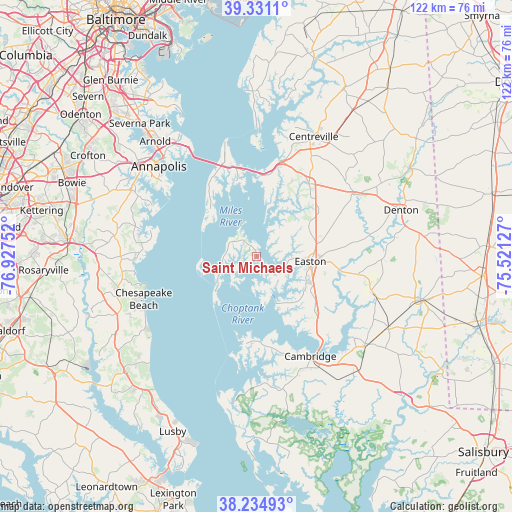
Saint Michaels GPS coordinates[2]
38° 47' 6.432" North, 76° 13' 27.804" West
| Map corner | latitude | longitude |
|---|---|---|
| Upper-left | 39.3311°, | -76.92752° |
| Center: | 38.78512°, | -76.22439° |
| Lower-right: | 38.23493°, | -75.52127° |
| Map W x H: | 121.9×121.9 km | = 75.7×75.7mi |
| max Lat: | 71.29058° ⇑56.7% North |
| Saint Michaels: | 38.78512° |
| min Lat: | ⇓43.3% South 19.06759° |
| min Long | Saint Michaels | max Long |
| -171.73463° | -76.22439° | -66.98998° |
| W 83.4%⇐ | ⇒16.6% E |
Elevation
Elevation of Saint Michaels is 3 m = 10 ft, and this is 291.8 m = 957 ft below average elevation for this country.
| Max E: |
3189 m = 10463 ft | 99.1% |
| Avg. | 294.8 m = 967 ft | |
| Saint Michaels | 3 m = 10 ft | |
Min E: |
-60 m = -197 ft | 0.9% |
See also: United States elevation on elevation.city.
Geographical zone
Saint Michaels is located in North temperate zone (between Tropic of Cancer and the Arctic Circle). Distance of this Northern Tropic circle is 1706.6 km =1060.4 mi to South.| Distance of | km | miles | from Saint Michaels |
|---|---|---|---|
| North Pole | 5694.6 | 3538.5 | to North |
| Arctic Circle | 3088.7 | 1919.2 | to North |
| Tropic Cancer | 1706.6 | 1060.4 | to South |
| Equator | 4312.5 | 2679.7 | to South |


Nearby cities:
15 places around Saint Michaels: (largest is in red/bold)
• Algonquin
24.7 km =15.3 mi,  155°
155°
• Cambridge
27.7 km =17.2 mi,  152°
152°
• Chester
21.9 km =13.6 mi,  345°
345°
• Cordova
22.2 km =13.8 mi,  63°
63°
• Easton
12.9 km =8 mi,  95°
95°
• Grasonville
19.3 km =12 mi,  3°
3°
• Kent Narrows
20.5 km =12.7 mi,  356°
356°
• Mayo
27.4 km =17 mi,  294°
294°
• North Beach
28 km =17.4 mi,  251°
251°
• Oxford
11.9 km =7.4 mi, 157°
• Queenstown
23.6 km =14.7 mi,  14°
14°
• Shady Side
25.7 km =16 mi,  284°
284°
• Stevensville
23.1 km =14.4 mi,  340°
340°
• Tilghman Island
13.4 km =8.3 mi,  227°
227°
• Trappe
20.2 km =12.6 mi,  134°
134°
Sources, notices
• [Note1] Compared only with cities in United States existing in our database
• [Src1] Map data: © OpenStreetMap contributors (CC-BY-SA)
• [Src2] Other city data from geonames.org with taken over terms of usage.
• [Src3] Geographical zone / Annual Mean Temperature by Robert A. Rohde @ Wikipedia
