Benton geodata
Benton (Missouri) is a seat of a second-order administrative division; located in United States in America/Chicago (GMT-5) time zone. With population of 863 people, there are 17256 cities with bigger population in this country. Compared to other cities in United States, 65.7% of cities are located further ↑North; 57.7% of cities are located further →East and 63.8% of cities have higher elevation than Benton. Note1


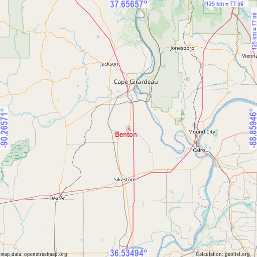
Benton GPS coordinates[2]
37° 5' 52.188" North, 89° 33' 45.288" West
| Map corner | latitude | longitude |
|---|---|---|
| Upper-left | 37.65657°, | -90.26571° |
| Center: | 37.09783°, | -89.56258° |
| Lower-right: | 36.53494°, | -88.85946° |
| Map W x H: | 124.7×124.7 km | = 77.5×77.5mi |
| max Lat: | 71.29058° ⇑65.7% North |
| Benton: | 37.09783° |
| min Lat: | ⇓34.3% South 19.06759° |
| min Long | Benton | max Long |
| -171.73463° | -89.56258° | -66.98998° |
| W 42.3%⇐ | ⇒57.7% E |
Elevation
Elevation of Benton is 134 m = 440 ft, and this is 160.8 m = 528 ft below average elevation for this country.
| Max E: |
3189 m = 10463 ft | 63.8% |
| Avg. | 294.8 m = 967 ft | |
| Benton | 134 m = 440 ft | |
Min E: |
-60 m = -197 ft | 36.2% |
See also: United States elevation on elevation.city.
Geographical zone
Benton is located in North temperate zone (between Tropic of Cancer and the Arctic Circle). Distance of this Northern Tropic circle is 1519 km =943.9 mi to South.| Distance of | km | miles | from Benton |
|---|---|---|---|
| North Pole | 5882.2 | 3655 | to North |
| Arctic Circle | 3276.3 | 2035.8 | to North |
| Tropic Cancer | 1519 | 943.9 | to South |
| Equator | 4124.9 | 2563.1 | to South |


Nearby cities:
15 places around Benton: (largest is in red/bold)
• Advance
30.8 km =19.1 mi,  271°
271°
• Bertrand
23.1 km =14.4 mi,  154°
154°
• Cape Girardeau
23.5 km =14.6 mi,  9°
9°
• Chaffee
12.3 km =7.6 mi,  318°
318°
• Charleston
27.2 km =16.9 mi,  136°
136°
• Kelso
10.4 km =6.5 mi, 6°
• Miner
23 km =14.3 mi,  174°
174°
• Morehouse
29.9 km =18.6 mi,  201°
201°
• Morley
7.4 km =4.6 mi,  215°
215°
• Mounds
32.4 km =20.1 mi,  86°
86°
• Olive Branch
20.3 km =12.6 mi,  67°
67°
• Oran
8.4 km =5.2 mi,  260°
260°
• Scott City
13.6 km =8.5 mi, 14°
• Sikeston
24.7 km =15.3 mi,  185°
185°
• Tamms
30.1 km =18.7 mi,  59°
59°
Sources, notices
• [Note1] Compared only with cities in United States existing in our database
• [Src1] Map data: © OpenStreetMap contributors (CC-BY-SA)
• [Src2] Other city data from geonames.org with taken over terms of usage.
• [Src3] Geographical zone / Annual Mean Temperature by Robert A. Rohde @ Wikipedia
