Charleston geodata
Charleston (Missouri) is a seat of a second-order administrative division; located in United States in America/Chicago (GMT-5) time zone. With population of 5,815 people, there are 6530 cities with bigger population in this country. Compared to other cities in United States, 66.5% of cities are located further ↑North; 57.1% of cities are located further →East and 70.3% of cities have higher elevation than Charleston. Note1
Administrative division(s):
- Level 1: Missouri
- Level 2: Mississippi County
- Level 3: Township of Tywappity


Charleston GPS coordinates[2]
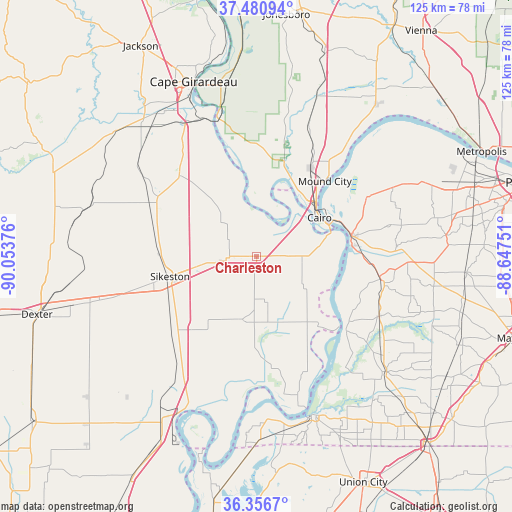
36° 55' 15.204" North, 89° 21' 2.268" West
| Map corner | latitude | longitude |
|---|---|---|
| Upper-left | 37.48094°, | -90.05376° |
| Center: | 36.92089°, | -89.35063° |
| Lower-right: | 36.3567°, | -88.64751° |
| Map W x H: | 125×125 km | = 77.7×77.7mi |
| max Lat: | 71.29058° ⇑66.5% North |
| Charleston: | 36.92089° |
| min Lat: | ⇓33.5% South 19.06759° |
| min Long | Charleston | max Long |
| -171.73463° | -89.35063° | -66.98998° |
| W 42.9%⇐ | ⇒57.1% E |
Elevation
Elevation of Charleston is 99 m = 325 ft, and this is 195.8 m = 642 ft below average elevation for this country.
| Max E: |
3189 m = 10463 ft | 70.3% |
| Avg. | 294.8 m = 967 ft | |
| Charleston | 99 m = 325 ft | |
Min E: |
-60 m = -197 ft | 29.7% |
See also: United States elevation on elevation.city.
Geographical zone
Charleston is located in North temperate zone (between Tropic of Cancer and the Arctic Circle). Distance of this Northern Tropic circle is 1499.3 km =931.6 mi to South.| Distance of | km | miles | from Charleston |
|---|---|---|---|
| North Pole | 5901.8 | 3667.2 | to North |
| Arctic Circle | 3296 | 2048 | to North |
| Tropic Cancer | 1499.3 | 931.6 | to South |
| Equator | 4105.2 | 2550.9 | to South |


Nearby cities:
15 places around Charleston: (largest is in red/bold)
• Bardwell
30.8 km =19.1 mi,  100°
100°
• Barlow
30.7 km =19.1 mi,  61°
61°
• Benton
27.2 km =16.9 mi,  316°
316°
• Bertrand
9.2 km =5.7 mi,  262°
262°
• Cairo
18.1 km =11.2 mi, 58°
• East Prairie
16 km =9.9 mi,  191°
191°
• Matthews
27.7 km =17.2 mi,  229°
229°
• Miner
17 km =10.6 mi, 258°
• Morehouse
30.9 km =19.2 mi,  254°
254°
• Morley
26.8 km =16.7 mi,  300°
300°
• Mound City
24.8 km =15.4 mi,  42°
42°
• Mounds
25.4 km =15.8 mi,  32°
32°
• Olive Branch
27.5 km =17.1 mi,  359°
359°
• Sikeston
21.7 km =13.5 mi, 256°
• Wickliffe
23.7 km =14.7 mi,  78°
78°
Sources, notices
• [Note1] Compared only with cities in United States existing in our database
• [Src1] Map data: © OpenStreetMap contributors (CC-BY-SA)
• [Src2] Other city data from geonames.org with taken over terms of usage.
• [Src3] Geographical zone / Annual Mean Temperature by Robert A. Rohde @ Wikipedia
