Carl Junction geodata
Carl Junction (Missouri) is a populated place; located in United States in America/Chicago (GMT-5) time zone. With population of 7,729 people, there are 5407 cities with bigger population in this country. Compared to other cities in United States, 65.4% of cities are located further ↑North; 70% of cities are located further →East and 67.6% of cities have lower elevation than Carl Junction. Note1
Administrative division(s):
- Level 1: Missouri
- Level 2: Jasper County
- Level 3: Township of Twin Groves


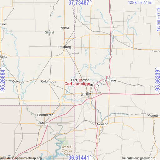
Carl Junction GPS coordinates[2]
37° 10' 36.192" North, 94° 33' 55.836" West
| Map corner | latitude | longitude |
|---|---|---|
| Upper-left | 37.73487°, | -95.26864° |
| Center: | 37.17672°, | -94.56551° |
| Lower-right: | 36.61441°, | -93.86239° |
| Map W x H: | 124.6×124.6 km | = 77.4×77.4mi |
| max Lat: | 71.29058° ⇑65.4% North |
| Carl Junction: | 37.17672° |
| min Lat: | ⇓34.6% South 19.06759° |
| min Long | Carl Junction | max Long |
| -171.73463° | -94.56551° | -66.98998° |
| W 30%⇐ | ⇒70% E |
Elevation
Elevation of Carl Junction is 274 m = 899 ft, and this is 20.8 m = 68 ft below average elevation for this country.
| Max E: |
3189 m = 10463 ft | 32.4% |
| Avg. | 294.8 m = 967 ft | |
| Carl Junction | 274 m = 899 ft | |
Min E: |
-60 m = -197 ft | 67.6% |
See also: United States elevation on elevation.city.
Geographical zone
Carl Junction is located in North temperate zone (between Tropic of Cancer and the Arctic Circle). Distance of this Northern Tropic circle is 1527.7 km =949.3 mi to South.| Distance of | km | miles | from Carl Junction |
|---|---|---|---|
| North Pole | 5873.4 | 3649.6 | to North |
| Arctic Circle | 3267.5 | 2030.3 | to North |
| Tropic Cancer | 1527.7 | 949.3 | to South |
| Equator | 4133.7 | 2568.6 | to South |


Nearby cities:
15 places around Carl Junction: (largest is in red/bold)
• Airport Drive
6.2 km =3.9 mi,  128°
128°
• Alba
14.8 km =9.2 mi,  62°
62°
• Baxter Springs
22.7 km =14.1 mi,  221°
221°
• Carterville
11.3 km =7 mi,  105°
105°
• Carthage
22.6 km =14 mi,  90°
90°
• Duenweg
17 km =10.6 mi, 127°
• Duquesne
14.6 km =9.1 mi,  139°
139°
• Galena
13 km =8.1 mi,  210°
210°
• Joplin
11.3 km =7 mi,  155°
155°
• Leawood
16.7 km =10.4 mi, 158°
• Loma Linda
20.7 km =12.9 mi,  185°
185°
• Oronogo
8.5 km =5.3 mi,  81°
81°
• Riverton
16.7 km =10.4 mi,  227°
227°
• Silver Creek
17.2 km =10.7 mi,  151°
151°
• Webb City
9.7 km =6 mi, 110°
Sources, notices
• [Note1] Compared only with cities in United States existing in our database
• [Src1] Map data: © OpenStreetMap contributors (CC-BY-SA)
• [Src2] Other city data from geonames.org with taken over terms of usage.
• [Src3] Geographical zone / Annual Mean Temperature by Robert A. Rohde @ Wikipedia
