Joplin geodata
Joplin (Missouri) is a populated place; located in United States in America/Chicago (GMT-5) time zone. With population of 51,818 people, there are 911 cities with bigger population in this country. Compared to other cities in United States, 65.8% of cities are located further ↑North; 69.9% of cities are located further →East and 74.2% of cities have lower elevation than Joplin. Note1


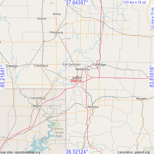
Joplin GPS coordinates[2]
37° 5' 3.228" North, 94° 30' 47.808" West
| Map corner | latitude | longitude |
|---|---|---|
| Upper-left | 37.64307°, | -95.21641° |
| Center: | 37.08423°, | -94.51328° |
| Lower-right: | 36.52124°, | -93.81016° |
| Map W x H: | 124.7×124.7 km | = 77.5×77.5mi |
| max Lat: | 71.29058° ⇑65.8% North |
| Joplin: | 37.08423° |
| min Lat: | ⇓34.2% South 19.06759° |
| min Long | Joplin | max Long |
| -171.73463° | -94.51328° | -66.98998° |
| W 30.1%⇐ | ⇒69.9% E |
Elevation
Elevation of Joplin is 308 m = 1010 ft, and this is 13.2 m = 43 ft above average elevation for this country.
| Max E: |
3189 m = 10463 ft | 25.8% |
| Joplin | 308 m 1010 ft | |
| Avg. | 294.8 m = 967 ft | |
Min E: |
-60 m = -197 ft | 74.2% |
See also: Joplin elevation on elevation.city.
Geographical zone
Joplin is located in North temperate zone (between Tropic of Cancer and the Arctic Circle). Distance of this Northern Tropic circle is 1517.5 km =942.9 mi to South.| Distance of | km | miles | from Joplin |
|---|---|---|---|
| North Pole | 5883.7 | 3656 | to North |
| Arctic Circle | 3277.8 | 2036.7 | to North |
| Tropic Cancer | 1517.5 | 942.9 | to South |
| Equator | 4123.4 | 2562.2 | to South |


Nearby cities:
15 places around Joplin: (largest is in red/bold)
• Airport Drive
6.5 km =4 mi,  1°
1°
• Alba
19.1 km =11.9 mi,  26°
26°
• Carl Junction
11.3 km =7 mi,  335°
335°
• Carterville
9.5 km =5.9 mi,  40°
40°
• Carthage
20.7 km =12.9 mi,  60°
60°
• Diamond
20.1 km =12.5 mi,  119°
119°
• Duenweg
8.8 km =5.5 mi,  90°
90°
• Duquesne
4.9 km =3 mi,  99°
99°
• Galena
11.2 km =7 mi,  265°
265°
• Leawood
5.4 km =3.4 mi,  164°
164°
• Loma Linda
12.2 km =7.6 mi,  212°
212°
• Oronogo
12.2 km =7.6 mi,  18°
18°
• Riverton
17 km =10.6 mi, 266°
• Silver Creek
6 km =3.7 mi,  143°
143°
• Webb City
8.2 km =5.1 mi, 32°
Sources, notices
• [Note1] Compared only with cities in United States existing in our database
• [Src1] Map data: © OpenStreetMap contributors (CC-BY-SA)
• [Src2] Other city data from geonames.org with taken over terms of usage.
• [Src3] Geographical zone / Annual Mean Temperature by Robert A. Rohde @ Wikipedia
