Hazelwood geodata
Hazelwood (Missouri) is a populated place; located in United States in America/Chicago (GMT-5) time zone. With population of 25,661 people, there are 1952 cities with bigger population in this country. Compared to other cities in United States, 56.8% of cities are located further ↑North; 60.4% of cities are located further →East and 56.6% of cities have higher elevation than Hazelwood. Note1
Administrative division(s):
- Level 1: Missouri
- Level 2: Saint Louis County
- Level 3: Township of Airport


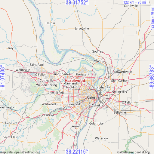
Hazelwood GPS coordinates[2]
38° 46' 17.184" North, 90° 22' 15.42" West
| Map corner | latitude | longitude |
|---|---|---|
| Upper-left | 39.31752°, | -91.07408° |
| Center: | 38.77144°, | -90.37095° |
| Lower-right: | 38.22115°, | -89.66783° |
| Map W x H: | 121.9×121.9 km | = 75.7×75.7mi |
| max Lat: | 71.29058° ⇑56.8% North |
| Hazelwood: | 38.77144° |
| min Lat: | ⇓43.2% South 19.06759° |
| min Long | Hazelwood | max Long |
| -171.73463° | -90.37095° | -66.98998° |
| W 39.6%⇐ | ⇒60.4% E |
Elevation
Elevation of Hazelwood is 173 m = 568 ft, and this is 121.8 m = 400 ft below average elevation for this country.
| Max E: |
3189 m = 10463 ft | 56.6% |
| Avg. | 294.8 m = 967 ft | |
| Hazelwood | 173 m = 568 ft | |
Min E: |
-60 m = -197 ft | 43.4% |
See also: United States elevation on elevation.city.
Geographical zone
Hazelwood is located in North temperate zone (between Tropic of Cancer and the Arctic Circle). Distance of this Northern Tropic circle is 1705.1 km =1059.5 mi to South.| Distance of | km | miles | from Hazelwood |
|---|---|---|---|
| North Pole | 5696.1 | 3539.4 | to North |
| Arctic Circle | 3090.2 | 1920.2 | to North |
| Tropic Cancer | 1705.1 | 1059.5 | to South |
| Equator | 4311 | 2678.7 | to South |


Nearby cities:
15 places around Hazelwood: (largest is in red/bold)
• Bel-Ridge
7.9 km =4.9 mi,  150°
150°
• Berkeley
3.9 km =2.4 mi,  118°
118°
• Breckenridge Hills
6.3 km =3.9 mi,  177°
177°
• Bridgeton
3.6 km =2.2 mi,  262°
262°
• Calverton Park
5 km =3.1 mi,  98°
98°
• Cool Valley
7.2 km =4.5 mi,  132°
132°
• Dellwood
7.8 km =4.8 mi,  108°
108°
• Edmundson
4 km =2.5 mi,  171°
171°
• Ferguson
6.4 km =4 mi, 118°
• Florissant
4.6 km =2.9 mi,  64°
64°
• Overland
7.9 km =4.9 mi, 174°
• Saint Ann
5 km =3.1 mi,  192°
192°
• Saint John
6.6 km =4.1 mi,  161°
161°
• Saint Johns
6.9 km =4.3 mi, 159°
• Woodson Terrace
5.3 km =3.3 mi, 168°
Sources, notices
• [Note1] Compared only with cities in United States existing in our database
• [Src1] Map data: © OpenStreetMap contributors (CC-BY-SA)
• [Src2] Other city data from geonames.org with taken over terms of usage.
• [Src3] Geographical zone / Annual Mean Temperature by Robert A. Rohde @ Wikipedia
