Maryland Heights geodata
Maryland Heights (Missouri) is a populated place; located in United States in America/Chicago (GMT-5) time zone. With population of 27,389 people, there are 1831 cities with bigger population in this country. Compared to other cities in United States, 57.3% of cities are located further ↑North; 60.6% of cities are located further →East and 58.6% of cities have higher elevation than Maryland Heights. Note1
Administrative division(s):
- Level 1: Missouri
- Level 2: Saint Louis County
- Level 3: Township of Midland


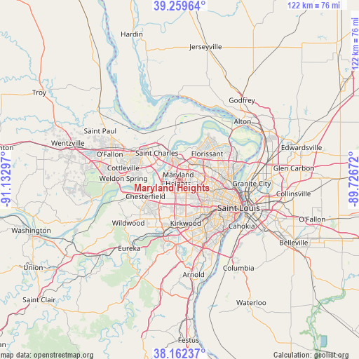
Maryland Heights GPS coordinates[2]
38° 42' 47.196" North, 90° 25' 47.424" West
| Map corner | latitude | longitude |
|---|---|---|
| Upper-left | 39.25964°, | -91.13297° |
| Center: | 38.71311°, | -90.42984° |
| Lower-right: | 38.16237°, | -89.72672° |
| Map W x H: | 122×122 km | = 75.8×75.8mi |
| max Lat: | 71.29058° ⇑57.3% North |
| Maryland Heights: | 38.71311° |
| min Lat: | ⇓42.7% South 19.06759° |
| min Long | Maryland Height | max Long |
| -171.73463° | -90.42984° | -66.98998° |
| W 39.4%⇐ | ⇒60.6% E |
Elevation
Elevation of Maryland Heights is 162 m = 531 ft, and this is 132.8 m = 436 ft below average elevation for this country.
| Max E: |
3189 m = 10463 ft | 58.6% |
| Avg. | 294.8 m = 967 ft | |
| Maryland Heights | 162 m = 531 ft | |
Min E: |
-60 m = -197 ft | 41.4% |
See also: United States elevation on elevation.city.
Geographical zone
Maryland Heights is located in North temperate zone (between Tropic of Cancer and the Arctic Circle). Distance of this Northern Tropic circle is 1698.6 km =1055.5 mi to South.| Distance of | km | miles | from Maryland Heights |
|---|---|---|---|
| North Pole | 5702.6 | 3543.4 | to North |
| Arctic Circle | 3096.7 | 1924.2 | to North |
| Tropic Cancer | 1698.6 | 1055.5 | to South |
| Equator | 4304.5 | 2674.7 | to South |


Nearby cities:
15 places around Maryland Heights: (largest is in red/bold)
• Breckenridge Hills
5.4 km =3.4 mi,  88°
88°
• Bridgeton
6.2 km =3.9 mi,  14°
14°
• Charlack
7.6 km =4.7 mi,  98°
98°
• Creve Coeur
5.8 km =3.6 mi,  173°
173°
• Edmundson
6.2 km =3.9 mi,  66°
66°
• Hazelwood
8.3 km =5.2 mi,  38°
38°
• Ladue
8.2 km =5.1 mi,  148°
148°
• Olivette
7.1 km =4.4 mi,  138°
138°
• Overland
6 km =3.7 mi, 102°
• Saint Ann
4.3 km =2.7 mi, 68°
• Saint John
7.3 km =4.5 mi, 88°
• Saint Johns
7.5 km =4.7 mi, 89°
• Sycamore Hills
7.1 km =4.4 mi, 101°
• Vinita Park
8 km =5 mi,  108°
108°
• Woodson Terrace
6.3 km =3.9 mi,  77°
77°
Sources, notices
• [Note1] Compared only with cities in United States existing in our database
• [Src1] Map data: © OpenStreetMap contributors (CC-BY-SA)
• [Src2] Other city data from geonames.org with taken over terms of usage.
• [Src3] Geographical zone / Annual Mean Temperature by Robert A. Rohde @ Wikipedia
