Park Hills geodata
Park Hills (Missouri) is a populated place; located in United States in America/Chicago (GMT-5) time zone. With population of 8,692 people, there are 4928 cities with bigger population in this country. Compared to other cities in United States, 62.4% of cities are located further ↑North; 60.9% of cities are located further →East and 58.2% of cities have lower elevation than Park Hills. Note1
Administrative division(s):
- Level 1: Missouri
- Level 2: Saint Francois County
- Level 3: Township of Saint Francois


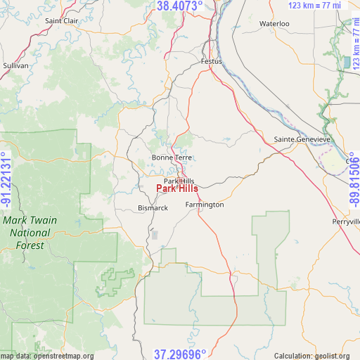
Park Hills GPS coordinates[2]
37° 51' 15.192" North, 90° 31' 5.448" West
| Map corner | latitude | longitude |
|---|---|---|
| Upper-left | 38.4073°, | -91.22131° |
| Center: | 37.85422°, | -90.51818° |
| Lower-right: | 37.29696°, | -89.81506° |
| Map W x H: | 123.5×123.5 km | = 76.7×76.7mi |
| max Lat: | 71.29058° ⇑62.4% North |
| Park Hills: | 37.85422° |
| min Lat: | ⇓37.6% South 19.06759° |
| min Long | Park Hills | max Long |
| -171.73463° | -90.51818° | -66.98998° |
| W 39.1%⇐ | ⇒60.9% E |
Elevation
Elevation of Park Hills is 231 m = 758 ft, and this is 63.8 m = 209 ft below average elevation for this country.
| Max E: |
3189 m = 10463 ft | 41.8% |
| Avg. | 294.8 m = 967 ft | |
| Park Hills | 231 m = 758 ft | |
Min E: |
-60 m = -197 ft | 58.2% |
See also: United States elevation on elevation.city.
Geographical zone
Park Hills is located in North temperate zone (between Tropic of Cancer and the Arctic Circle). Distance of this Northern Tropic circle is 1603.1 km =996.1 mi to South.| Distance of | km | miles | from Park Hills |
|---|---|---|---|
| North Pole | 5798.1 | 3602.8 | to North |
| Arctic Circle | 3192.2 | 1983.5 | to North |
| Tropic Cancer | 1603.1 | 996.1 | to South |
| Equator | 4209 | 2615.4 | to South |


Nearby cities:
15 places around Park Hills: (largest is in red/bold)
• Arcadia
31.2 km =19.4 mi,  198°
198°
• Bismarck
13.3 km =8.3 mi,  224°
224°
• Bonne Terre
8.3 km =5.2 mi,  336°
336°
• Desloge
2 km =1.2 mi, 336°
• Doe Run
12.5 km =7.8 mi,  171°
171°
• Elvins
2.3 km =1.4 mi,  213°
213°
• Esther
1.8 km =1.1 mi,  104°
104°
• Farmington
11.8 km =7.3 mi,  133°
133°
• Flat River
0.5 km =0.3 mi, 165°
• Iron Mountain Lake
20.1 km =12.5 mi, 207°
• Ironton
30.1 km =18.7 mi, 198°
• Leadwood
6.7 km =4.2 mi,  282°
282°
• Pilot Knob
28.1 km =17.5 mi, 202°
• Potosi
25.4 km =15.8 mi,  291°
291°
• Terre du Lac
11.4 km =7.1 mi,  304°
304°
Sources, notices
• [Note1] Compared only with cities in United States existing in our database
• [Src1] Map data: © OpenStreetMap contributors (CC-BY-SA)
• [Src2] Other city data from geonames.org with taken over terms of usage.
• [Src3] Geographical zone / Annual Mean Temperature by Robert A. Rohde @ Wikipedia
