Peculiar geodata
Peculiar (Missouri) is a populated place; located in United States in America/Chicago (GMT-5) time zone. With population of 4,885 people, there are 7283 cities with bigger population in this country. Compared to other cities in United States, 57.2% of cities are located further ↑North; 69.8% of cities are located further →East and 74% of cities have lower elevation than Peculiar. Note1
Administrative division(s):
- Level 1: Missouri
- Level 2: Cass County
- Level 3: Township of West Peculiar


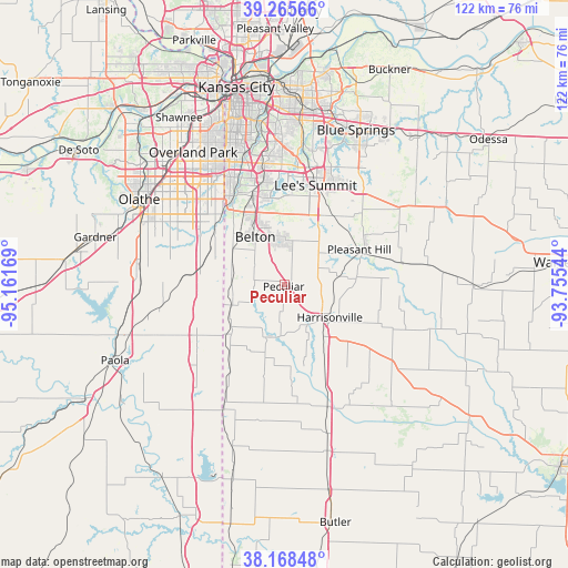
Peculiar GPS coordinates[2]
38° 43' 9.048" North, 94° 27' 30.816" West
| Map corner | latitude | longitude |
|---|---|---|
| Upper-left | 39.26566°, | -95.16169° |
| Center: | 38.71918°, | -94.45856° |
| Lower-right: | 38.16848°, | -93.75544° |
| Map W x H: | 122×122 km | = 75.8×75.8mi |
| max Lat: | 71.29058° ⇑57.2% North |
| Peculiar: | 38.71918° |
| min Lat: | ⇓42.8% South 19.06759° |
| min Long | Peculiar | max Long |
| -171.73463° | -94.45856° | -66.98998° |
| W 30.2%⇐ | ⇒69.8% E |
Elevation
Elevation of Peculiar is 307 m = 1007 ft, and this is 12.2 m = 40 ft above average elevation for this country.
| Max E: |
3189 m = 10463 ft | 26% |
| Peculiar | 307 m 1007 ft | |
| Avg. | 294.8 m = 967 ft | |
Min E: |
-60 m = -197 ft | 74% |
See also: United States elevation on elevation.city.
Geographical zone
Peculiar is located in North temperate zone (between Tropic of Cancer and the Arctic Circle). Distance of this Northern Tropic circle is 1699.3 km =1055.9 mi to South.| Distance of | km | miles | from Peculiar |
|---|---|---|---|
| North Pole | 5701.9 | 3543 | to North |
| Arctic Circle | 3096 | 1923.8 | to North |
| Tropic Cancer | 1699.3 | 1055.9 | to South |
| Equator | 4305.2 | 2675.1 | to South |


Nearby cities:
15 places around Peculiar: (largest is in red/bold)
• Archie
27.9 km =17.3 mi,  161°
161°
• Belton
12.1 km =7.5 mi,  328°
328°
• Cleveland
12.5 km =7.8 mi,  249°
249°
• Drexel
29.7 km =18.5 mi,  206°
206°
• Garden City
29.1 km =18.1 mi,  127°
127°
• Grandview
19.6 km =12.2 mi,  340°
340°
• Greenwood
17.8 km =11.1 mi,  34°
34°
• Harrisonville
12 km =7.5 mi, 127°
• Lake Lotawana
29.3 km =18.2 mi,  39°
39°
• Lake Winnebago
15.2 km =9.4 mi, 34°
• Lee's Summit
22.3 km =13.9 mi,  17°
17°
• Loch Lloyd
17.3 km =10.7 mi,  315°
315°
• Louisburg
22.3 km =13.9 mi,  240°
240°
• Pleasant Hill
18.1 km =11.2 mi,  65°
65°
• Raymore
9.2 km =5.7 mi,  3°
3°
Sources, notices
• [Note1] Compared only with cities in United States existing in our database
• [Src1] Map data: © OpenStreetMap contributors (CC-BY-SA)
• [Src2] Other city data from geonames.org with taken over terms of usage.
• [Src3] Geographical zone / Annual Mean Temperature by Robert A. Rohde @ Wikipedia
